
![]()
GREENBELT COALITION OF CANADA’S
CAPITAL REGION
Position Paper for the
NCC’s Greenbelt Master Plan Review
September 2010
Table of Contents
1.4 The 1996 Greenbelt Master Plan
2 THE GREENBELT COALITION’S VISION AND GOALS
3.5 Lifestyle and recreational values
4.2 Intensification and the Greenbelt
5.1 Aesthetics and public ownership
5.2 Legal protection and territorial integrity
5.3 The Emerald Necklace Vision
5.7 Public participation, education, partnerships and stewardship
Appendix 1 – Greenbelt Coalition Member Organizations
Appendix 2 – The NCC’s Legal Framework for the Purchase and Disposal of Land
Appendix 3 – The Natural Environment – More Detailed Analysis and Recommendations
Appendix 5 – Initial Proposals for Greenbelt Expansion
EXECUTIVE SUMMARY
The Greenbelt Coalition was formed in the fall of 2008 to provide a strong community-based voice in relation to the NCC’s review of the 1996 Greenbelt Master Plan. The Coalition comprises virtually all the major environmental organizations in the National Capital Region and the Federation of Citizens’ Associations of Ottawa-Carleton (FCA).
The Coalition is promoting the following Greenbelt vision:
“We see the National Capital Greenbelt as part of our national heritage and an essential component of the national capital’s “emerald necklace” that makes Canada’s capital a truly unique green city to live in and visit. This “necklace” also encompasses and links Gatineau Park, the other National Interest Land Mass (NILM) lands such as Leamy Lake and the Poets’ Pathway, other NCC green spaces such as the parkways, as well as the Central Experimental Farm. We see the Greenbelt as a “natural oasis” with expansive views of the Capital, significant natural forest, field, and wetland ecosystems, and agricultural, and heritage landscapes – a model of biodiversity in an urban setting. This “green structure” will enable a diversity of activities within a city aiming to be part of a sustainable ecosystem.”
As well, more recently, we have identified the need for an expanded Greenbelt to complete the Emerald Necklace with important natural areas such as the South March Highlands and the Leitrim Wetland complex, and this has become an additional core element of our vision.
In this report, the Coalition has explored many issues and opportunities for the Greenbelt. The main points we would like to emphasize are:
A. Protection and enhancement of Biodiversity should be the key consideration in planning for and managing the Greenbelt. Protecting and enhancing biodiversity requires action well beyond the officially identified ecologically valuable sites. The diverse wildlife and plant species within the Greenbelt should be recognized, valued and protected. Wildlife corridors, riparian buffers and other natural links, as well as habitat for species at risk need to be identified, rehabilitated and protected. A comprehensive Wildlife Strategy should be developed and implemented. Planning should be done from an ecosystem perspective. Adequate protection of the Greenbelt must involve the concept of ecological stewardship, which promotes long-term health and sustainability.
B. The Greenbelt should be defined in federal statutes, with its boundaries clearly delineated, in approximation to the legal provisions currently afforded Canada’s National Parks under the National Parks Act. The NCC should be given the authority to ensure the protection of all federal lands within the Greenbelt, including those lands leased or under the jurisdiction of other federal departments and agencies. The Greenbelt should remain in public ownership.
C. The Greenbelt should be expanded to include lands that meet certain criteria. Priority areas for expansion are the Leitrim Wetland and the South March Highlands.
D. There should be no new transportation corridors in the Greenbelt.
E. The Coalition strongly opposes any new residential, commercial or institutional buildings in the Greenbelt. The Compatible Built Facilities role and the Buildable Site Area land designations should no longer exist in the revised Master Plan. The fact of existing built facilities should be recognized, allowing for preservation where this is in the public interest.
F. The ecological integrity and viability of the Greenbelt’s agricultural and rural lands should be preserved, protected and enhanced. Farmers should be given incentives to operate Greenbelt farms, and the economic viability of farm operations should be improved and enhanced. New forms of farming (horticulture, organic, vegetable, allotment gardens) should be re-introduced to complement existing operations (guided by the benefits of growing food close to home). Hay-cutting practices should be reviewed. A shared vision should be developed among stakeholders and the NCC for the integrated management of the natural environment and agriculture lands. The public should be educated about the benefits and requirements of farming.
G. The NCC should make a concerted effort to build a broad base of community partners as part of ongoing advice and assistance with Greenbelt planning, policy and operations. In this regard, the NCC should establish a Public Participation Policy with respect to the Greenbelt, making a commitment to citizens that administrative and policy processes will be open and accessible, respectful of the public’s right to be involved, and responsive to the public’s need for information. This policy should also involve the development and implementation of programs that provide the foundation for encouraging citizen participation and stewardship, extending outreach to non-traditional users and forging partnerships with a variety of constituencies.
If the National Capital Greenbelt is to flourish, it will need to enlist a broad base of community partners, similar to the Friends of the Greenbelt Foundation in Toronto. Having local citizens and community groups as part of an on-going mechanism to advise and assist with Greenbelt planning, policy and operations will do a great deal to increase awareness among a wider constituency, build a foundation of stronger community support, and provide a base of committed volunteers for a variety of programming needs.
Finally, the Coalition believes that the NCC has taken a number of positive steps in the last three years to make its decision-making more transparent and has established good working relations with its community partners. However, more needs to be done to ensure that the NCC fulfills its role as a strong and proactive environmental steward of the Greenbelt. We hope that additional changes to Bill C-20 will provide the authority for the NCC to effectively exert its leadership and protective role over all federal lands in the National Capital Greenbelt. We also hope that the analysis and recommendations in this Greenbelt Coalition report will encourage and further enable the NCC in this leadership role.
1 INTRODUCTION
1.1 Purpose
This Position Paper has two major objectives: (1) to provide input to the National Capital Commission’s (NCC) Greenbelt Master Plan Review process from the 15 environmental and community organizations that comprise the Greenbelt Coalition (see Appendix 1); and, (2) to inform the public on what we see as the major current and future issues regarding the National Capital Greenbelt. We seek to encourage public support for the preservation and enhancement of the Greenbelt and for our vision for the Greenbelt.
To put things in perspective, this initial Position Paper of the Greenbelt Coalition is a work-in-progress that was developed in relation to the various phases of the NCC Master Plan Review Process. The next phase, and perhaps the most critical part of this process relating to land uses within the Greenbelt, will take place in the fall of 2010. This process will culminate in the production by the NCC in 2011 of a new Master Plan for the Greenbelt with a time horizon of 50 years. While the Coalition’s overall vision for the Greenbelt, its objective, and its goals are unlikely to change significantly during the course of this process, with new information there may very well need to be additions or other changes to this document as the review process unfolds.
1.2 Background
Many years after it was first proposed, the National Capital Greenbelt was created in 1958 by a decision of the federal government. The Greenbelt comprises many assets in the National Capital Region, with a diversity of significant natural forest, field and wetland ecosystems, and agricultural and heritage land areas and landscapes. These assets will increasingly contribute not only to the image and quality of life of Canada’s capital region but also to the City of Ottawa’s declared policy, “to create a green and environmentally sensitive city.” Under successive federal governments, the Greenbelt has so far remained almost entirely federally-owned. However, there is presently no effective framework of legal protection, and some land that was acquired as Greenbelt has been sold primarily for infrastructure development (roads etc.) or, as in the case of Nortel, leased for an R&D campus facility.
During 2008, proposals for assigning parts of the Greenbelt to residential and other development were publicly advanced, first in an apparently casual remark by the NCC Chairperson, and shortly afterwards, by the City of Ottawa in a White Paper (WP) with the title, “Development in the Greenbelt.” Although City staff claimed that this WP merely examined some options, the presentation was biased, giving prominence to arguments for development, while presenting only a token examination of reasons for not doing this. Although the NCC is not bound by the City’s position, it does have a duty to consult widely, including with the City. Consequently, and bearing in mind the prior comment by the NCC Chairperson, this paper includes certain critiques of the WP. Please refer to the Coalition’s Position Paper on the WP for more information.1
1.3 Historical summary
The National Capital Greenbelt was created on the basis of recommendations in the Gréber Report,2 commissioned by Prime Minister Mackenzie King in 1936. This report, long in the making and interrupted by World War II, was completed and submitted to the Mackenzie King government in November 1949. But it was not until June 18, 1958, that Prime Minister John Diefenbaker rose in the House of Commons and announced that his government would make funds available to the Federal District Commission (the NCC’s predecessor) to purchase land in the National Capital Region for the creation of a Greenbelt. Thus began a painful expropriation of hundreds of local farms and other properties which, although acquired at what were deemed to be fair market prices, nevertheless ended the farming careers of many families and their descendants. Federal court challenges were initiated by some of the farmers, but all cases were lost because the Crown had – and continues to have – absolute authority in the area of land expropriation. As a result, the Greenbelt is almost entirely federally-owned, unlike some other designated Greenbelts such as the Greater Toronto Area’s Greenbelt, where the designation did not change the land ownership.
Until 1988, successive federal governments steadfastly maintained the sanctity of the Greenbelt, insofar as it was not treated as a land bank for local municipalities or commercial interests. The National Capital Act placed restrictions on the NCC’s ability to make land transactions, requiring Governor-in-Council approval for disposals above $10,000, in accordance with the Financial Administration Act and Regulations. Also, proceeds from any sale of lands were turned over to the Receiver General of Canada. In 1988 however, the National Capital Act was amended, allowing the NCC to keep the proceeds of land sales. In addition, the NCC’s budget was cut, forcing the NCC to sell some federal lands to help make up its budgetary shortfalls. (See Appendix 2 for the current and proposed legal framework.)
Following construction of the Hunt Club Road Extension in Nepean, the NCC developed plans for residential and commercial development on the severed Greenbelt lands between the new roadway and adjoining residential communities. These communities fought back, with the result that the severed lands were sold to the City of Ottawa as recreational lands, now referred to as Ben Franklin Park.
1.4 The 1996 Greenbelt Master Plan
The NCC’s 1996 Greenbelt Master Plan defines three major roles for the Greenbelt, each with an accompanying set of land designations (p. 35). There is firstly a “Continuous Natural Environment” role, with land designations of “Core Natural Area,” “Natural Buffer” and “Natural Area Link.” The second Greenbelt role is defined as “Vibrant Rural Community,” with “Cultivated Landscape” and “Rural Landscape” as land designations. The third role is entitled “Compatible Built Facilities,” with land designations of “Buildable Site Area” and “Infrastructure Corridor.”
This division into three major roles needs to be re-examined in light of the many environmental, economic and social changes that have occurred since the 1996 Master Plan. In Section 3, we address this by examining the aesthetic, public ownership, environmental, agricultural and lifestyle benefits (values) that the Greenbelt provides. In Section 4, we examine a number of actual or potential problems (issues): built facilities, intensification, infrastructure, long-term issues, legal protection, education and stewardship, and partnerships. These issues could impair the identified values if they are neglected, or addressed unwisely.
2 THE GREENBELT COALITION’S VISION AND GOALS
Before launching into a discussion of what we see as the major Greenbelt values, and issues relating to the current and future Greenbelt, it is important to understand the context that underlies our thinking. The Greenbelt Coalition was formed in the fall of 2008 to provide a strong community-based voice in relation to the NCC’s review of the 1996 Greenbelt Master Plan. The Coalition comprises virtually all the major environmental organizations in the National Capital Region and the Federation of Citizens’ Associations of Ottawa-Carleton (FCA).
One of the Coalition’s first tasks was to develop a vision for the future of the Greenbelt over the next 50 years, the time frame being used by the NCC in their review. The Coalition has proposed the following Greenbelt vision:
“We see the National Capital Greenbelt as part of our national heritage and an essential component of the national capital’s “emerald necklace” that makes Canada’s capital a truly unique green city to live in and visit. This “necklace” also encompasses and links Gatineau Park, the other National Interest Land Mass (NILM) lands such as Leamy Lake, the Poets’ Pathway, other NCC greenspaces such as the parkways, as well as, the Central Experimental Farm. We see the Greenbelt as a “natural oasis” with expansive views of the Capital, significant natural forest, field, and wetland ecosystems, and agricultural, and heritage landscapes – a model of biodiversity in an urban setting. This “green structure” will enable a diversity of activities within a city aiming to be part of a sustainable ecosystem.”
The Coalition’s overall objective is to promote our vision and the preservation and enhancement of the National Capital Greenbelt.
More specifically, the Coalition has developed the following set of proposed goals for the Greenbelt:
-
legally protecting the Greenbelt and keeping it in public ownership;
-
protecting the Greenbelt functions and boundaries as a biodiversity reserve;
-
ensuring that the principles of maintaining the Greenbelt’s ecological and territorial integrity and sustainable uses are followed;
-
maintaining and restoring biodiversity connections within the Greenbelt, as well as links to other natural areas in Ottawa, Eastern Ontario and Western Quebec;
-
enhancing natural areas within the Greenbelt and expanding the Greenbelt to complementary areas, such as the South March Highlands and Leitrim Wetlands to complete the Emerald Necklace;
-
ensuring that planning within and around the Greenbelt is consistent with the protection of the Greenbelt and its functions;
-
preserving and protecting the Greenbelt’s wild species;
-
maintaining wildlife corridors and restoring those that are now fragmented;
-
providing a more informed understanding and respect for wild species through policy, practice and education, in order to mitigate human-wildlife conflicts;
-
supporting the preservation and enhancement of agricultural lands;
-
creating and implementing a shared vision among the stakeholders and the NCC for the integrated management of the natural environment and agriculture lands;
-
ensuring that there are no new transportation corridors through the Greenbelt;
-
ensuring that there are no new residential, commercial or institutional buildings in the Greenbelt;
-
promoting public awareness of the value of the Greenbelt and encouraging public participation in the NCC Greenbelt Master Plan Review.
Comments on the NCC’s New Vision Statement and Associated Mission, Premises, Roles and Goals
On June 29, 2010 the NCC’s Board of Directors approved in principle the following long term (to 2060) Vision for the Greenbelt:
“The Greenbelt of the future will forever sustain dynamic natural systems of living and interconnected lands and waters that enrich life in Canada’s Capital Region and reflect Canadians’ timeless appreciation of our natural environment.”
This is clearly a very “green” vision for the Greenbelt, which indicates that the NCC has been responsive to what the public has been calling for during the Greenbelt consultation process. Nevertheless, members of the Greenbelt Coalition would have preferred to have the term “biodiversity” imbedded in the vision, a term that is prominent in the NCC’s own 2009 Environmental Strategy which states that the NCC will implement plans to preserve and protect biodiversity on its lands. The term biodiversity was also referred to frequently at both the Greenbelt Public Advisory Committee meeting in October 2009 and the National Visioning Forum in November 2009. We therefore urge the NCC to fully and explicitly integrate the biodiversity concept (see Appendix 3 of this paper) into its mission, roles and goals for the Greenbelt in the next step of its Master Plan planning process.
However, while there are many positive references to the natural environment in the various roles proposed by the NCC for the Greenbelt, there is also, in our view, a major dissonance, related to the “built facilities and transportation infrastructure” roles. The fact that the terms “environmentally sound”, “context-sensitive design” and “sustainable” are positioned next to these roles is in no way reassuring and does not diminish what we see as potential serious threats to the Greenbelt. In this connection, the Coalition’s position, as stated in our goals is very clear: we strongly oppose any new residential, commercial or institutional buildings in the Greenbelt, as well as any new transportation corridors that further fragment these lands. This position not only represents the view of the Coalition member organizations, but also reflects the strong opinions expressed at the National Visioning Workshop in November 2009, as well, as by the general public in their feedback to the NCC. As one federal cabinet minister so aptly expressed it, “Hands off the Greenbelt”.
Additional comments on built facilities can be found in Sections 4.1 to 4.3 of this paper.
3 GREENBELT VALUES
3.1 Aesthetic values
In his 1958 speech to the House of Commons, Prime Minister Diefenbaker stated: “I should like to emphasize that this is a long-term project undertaken in the national interest, that is necessary and essential if the capital of Canada is to be preserved and developed so that it will be a capital city of which this generation and succeeding generations can and will be proud.”
The Greenbelt, together with Gatineau Park and other natural lands, and including the three major rivers, comprise the National Capital Region’s “Emerald Necklace”, a showcase demonstrating to the world Canada’s commitment to biodiversity conservation in and around its capital city. Many cities now have a Greenbelt, but the National Capital Greenbelt, lying between the central city and the satellite communities, and having almost no residential areas within it, is one of the assets that makes Ottawa special. Its green continuity brings prestige, proclaiming: “We are a nation that values its ecological past, and we are actively planning for a sustainable future.” If there is any lack of appreciation elsewhere in Canada for these major assets of the nation’s capital, this is because, unlike in other nations, little has been done to inform Canadians about this part of their heritage. With modest effort, Canadians could be brought to regard their own capital city with as much pride as Americans regard Washington, and the citizens of other nations respectively regard Berlin, Brasilia, Canberra, Paris or Stockholm.
Most residents of the national capital region know about some elements of the Greenbelt, but many are not aware of its full extent. This is understandable because there is no signage along roads and there are no handy maps of the Greenbelt as a whole. In short, both the local community and the rest of Canada and the world could benefit from better promotion and education about the Greenbelt.
3.2 Public ownership values
A major difference between our Greenbelt and that of many other cities, such as the Greater Toronto Area (GTA), is that most of the land is in public ownership, acquired by expropriation. The GTA’s Southern Ontario Greenbelt legislation sets limits on development, but most of the land remains in private ownership. Any proposal to change the uses of those lands for public benefit would require landowner cooperation, or expropriation. The NCC Greenbelt is virtually free from any such encumbrance. To disperse more of this land back into private ownership would still further betray the sacrifices that were forced upon so many farmers and other residents.
3.3 Environmental values
Environmental values revolve around ecological continuity. Continuity provides migration corridors, which allow native flora and fauna to flourish, or regenerate after population decline, whether caused by natural effects such as seasonal changes or by disease, or by human actions, or combinations of these.
The Greenbelt includes two nationally important ecosystems: Mer Bleue (a Ramsar site) and the Medeola Woods, and several other major natural areas, notably Stony Swamp, Green’s Creek and Shirley’s Bay. These areas of highest value are ecologically linked together by undeveloped greenspace, including wetlands. Such lands are referred to by some, who may have development designs on them, as ‘scrub lands’, but they should not be considered to have lower ecological value merely because they lack the biological richness of the major identified lands. The ecological integrity provided by a large unbroken area of undeveloped land is just as important as the intrinsic value of the most important areas considered in isolation. In sum, the phrase “the whole is greater than the sum of its parts” best characterizes the value of the entire Greenbelt.
A more detailed description of the Greenbelt’s natural environment values is provided in Appendix 3. The ecological benefits of the Greenbelt extend well beyond its boundaries, particularly where wildlife corridors connect with other regional natural areas. The benefits for pollination, for example, are further discussed under agriculture in Section 3.4. Also discussed there are practical measures that would allow the agricultural lands to contribute better to environmental values, an opportunity which is at present not well reflected in NCC tenant policies.
In terms of human health, the fact that the Greenbelt spaces out the communities of amalgamated Ottawa provides air quality benefits. Clean air is carried to the city by the continental winds. During temperature inversions with no convection and little wind, air quality deteriorates, but the Greenbelt provides a reservoir of clean air, helping to preserve Ottawa’s air quality during adverse conditions. This benefit is nowhere mentioned in the discussion in the City’s WP, which states only that pollution is generated by motor traffic in the Greenbelt’s road corridors. The implication that Ottawa’s air quality is actually degraded by having a Greenbelt is not credible.
Recent NCC policy has been that natural lands disturbed by previous farming, tree planting or other uses should be allowed to revert to nature without intervention. However, much of this land is being adversely affected by the spread of invasive alien plant species such as Pale Swallowwort or Dog-strangling Vine (Cynanchum rossicum), Garlic Mustard (Alliaria petiolata), and Buckthorn (Rhamnus sp.). The result has been major displacement of native shrubs such as Hawthorn (Crataegus sp.), Chokecherry (Prunus Virginianus) and Staghorn Sumac (Rhus typhina). In the June 2009 document entitled “NCC Environmental Strategy – A framework for environmental leadership in Canada’s Capital,” the NCC lists as an objective: “Amount of NCC urban land infested by aggressive invasive plant species will be reduced by 10% against a baseline by 2014.” We agree that programs to control invasive species should be introduced. To be practical and effective, such programs will need to elicit help from volunteers, which has not been favoured in past NCC policy. However, there are precedents for engaging volunteers to control invasive plants. For example, in 2008, volunteers assisted in an Ontario Ministry of Natural Resources program for the control of Water Chestnut (Trapa natans) on the Ottawa River in Voyageur Provincial Park. Another parallel (involving cutting of trees greater in size than Buckthorn trees) is the use of volunteers to maintain canoe portages in Algonquin Provincial Park. And, following the major ice storm in 1998, the NCC had help from volunteers in clearing Gatineau Park ski trails. Clearly, the legal and other issues involving volunteers in this type of activity have been successfully addressed before. (The NCC also makes ample use of volunteers in its non-environmental programming activities.)
The National Capital Greenbelt runs as a ‘ribbon’ through the entire city. There is likely no other large city in the world that has such a diversity of wildlife within its borders. Wildlife can serve as an important ‘entry’ point for people to learn about the importance of protecting biodiversity. It represents a very tangible cultural and spiritual element for many.
The importance of wildlife to the public is reflected by the City of Ottawa’s recent commitment to develop a comprehensive Wildlife Strategy in collaboration with the NCC, other government agencies and community organizations, including representation from the Greenbelt Coalition. The strategy will be centred on wildlife-sensitive planning with a focus on public education and awareness programs. Other cities across Canada and the United States have adopted “Living with Wildlife” programs which can provide valuable models for Ottawa.
There has been a tendency to attempt to manage wildlife on the basis of individual species as opposed to considering broader ecosystem principles. Not only is this passé from an environmental perspective, but there is a growing body of research that demonstrates that a variety of species within forest, field and wetland ecosystems make important contributions to these habitats and need to be considered.
Protecting, restoring and expanding the Greenbelt would support Canada’s ratification of the 1992 Convention on Biological Diversity (CBD), the 1995 Canadian Biodiversity Strategy, and the City of Ottawa’s ecological sustainability goals. In addition, the Greenbelt could be the beginning of a network of trans-boundary ecological preserves and biosphere reserves to demonstrate Canada’s commitment to the CBD, and also to support Countdown 2010, an international initiative to halt biodiversity loss. What better place for such an initiative than the nation’s capital? Indeed, one of the Coalition’s members, the Ottawa Valley chapter of CPAWS, some years ago initiated the Algonquin to Adirondacks Conservation Program which aims to maintain and restore ecological linkages between Algonquin Provincial Park in Ontario and Adirondack State Park in New York State. The Greenbelt and rural lands in the Ottawa area form a critical part of this vision as they provide vital linkages to large wilderness areas north of Ottawa and beyond.
The preservation of the South March Highlands and Leitrim Wetlands and the incorporation of their unique qualities into the Greenbelt fit very well with this expansive view of the Greenbelt. This and other opportunities will be detailed in Appendix 5 of this paper.
3.4 Agricultural values
Present agricultural practices in the Greenbelt are, generally speaking, commercially successful and appropriate by existing standards, providing food, employment and income. However, for some time there have been trends towards reforming agricultural practices throughout Ontario, and in fact, world-wide. Reforms are happening as a result of various pressures and stresses, including ecological factors such as soil degradation, pollination issues, climate change and extreme weather events, energy and water shortages, and other threats. A revitalized Greenbelt Master Plan can position farming as a positive influence in this process. Comments from farm tenants include suggestions supporting our own views on creating a better future for Greenbelt agriculture. Obviously, farming tenants need market conditions that allow them to stay in business. Longer leases would help, but these should be coupled with requirements for some changes, as we indicate below.
Much of the world’s farmland has been described as an “ecological desert” as a consequence of monoculture crop production based on heavy use of fertilizers and pesticides. While this trend expanded world-wide over the last several decades, and was praised as the “green revolution” that would (but did not) end world hunger, its damaging ecological effects and long-term negative economic impacts were slow to be acknowledged. In the short and medium term, farmers made a better living, even while food prices came down in real terms. However, negative effects such as declining populations of wild bees and other insect pollinators are a warning to the farming community that all is not well in agriculture. So far as we know, populations of wild bees and other pollinators appear to remain healthy in natural land areas of the Greenbelt and continue to pollinate adjacent food crops that need them. In contrast, over much of North America, farm crops are beginning to suffer from catastrophic declines in domestic (mechanically transported) bee populations on which they have become reliant. Maintaining healthy pollinator populations through habitat protection and minimal use of pesticides is one way that the NCC can set a good example in the Greenbelt and point a way towards a sustainable future.
Maintaining habitat for ground-nesting birds, including those protected under the Migratory Birds Convention Act, is becoming a more urgent issue as grassland in the Greenbelt reverts to natural forest. Prior to human settlement, the grassland birds utilized habitat such as burnt forest land, wet meadows and long-grass prairie. As the extensive forested areas and other habitats were replaced by agriculture, the grassland birds adapted and continued to flourish, nesting in pasture lands and hayfields. This was possible in hayfields because hay cutting was traditionally done just once a year, allowing birds to raise broods before or after the cut. Present practice, however, is to make two or even three cuts a year. Early cutting of hayfields, while providing higher nutritive value in the hay, also destroys nests, eggs or young of many grassland bird species, including Bobolink, Eastern Meadowlark, Grasshopper Sparrow, Savannah Sparrow, Northern Harrier, Horned Lark, Upland Sandpiper and Common Snipe. The results are catastrophic because these birds are attracted to nest in hayfields, but then fail to reproduce. Many of these migratory birds, and others, are in serious decline for many reasons, but there is no doubt that the ground-nesting birds are seriously impacted by present-day hay cutting practices.
Not cutting hayfields until ground-nesting species have produced a first brood would be very helpful, but we realise that this would have significant implications for farmers. Indeed there may be no way to fully protect these bird species without impacting agricultural practices. However, declines in migratory bird populations have become so serious that strong efforts must be made. This should be viewed as another opportunity to reform farm practices to permit coexistence with nature, using expert advice from both wildlife specialists and farmers.
The underlying principle for the Greenbelt must be that leaving the protection of ground-nesting birds at the individual discretion of tenants is insufficient for their protection. Ultimately, the NCC as a federal agency is responsible for the protection of migratory birds on federal land. Some ideas to protect ground-nesting birds in Greenbelt farming are listed in Appendix 4 of this paper.
We understand that NCC farming tenants are being encouraged to manage land sustainably, but more can be done, including dissemination of best practices. As many farm tenants have suggested, the NCC should encourage increased food production for local markets, requiring less transportation energy, and as a result, creating less pollution. Greenbelt agriculture could set examples that farm operations elsewhere can adopt.
We note that many Greenbelt farm tenants expressed appreciation for their relatively privileged situation, by which some family members work in the city, while other family members work the land. In these tenants’ own words, “farming near a large population centre has its benefits.”
The Greenbelt’s agricultural land can be far more than just a place for food production as such. For a society that has come to think of food as growing on supermarket shelves, Greenbelt agriculture could be made more relevant by promoting agri-tourism, including school and educational tours. Again, these are suggestions made by farm tenants, with which we agree. The relative lack of such opportunities at present is in contrast to the vision conveyed in the 1996 Greenbelt Master Plan. It is stated there that it might take until the year 2020 to accomplish this vision, but presumably this was not intended to mean doing nothing until that arbitrary target date becomes imminent.
We comment here on equestrian operations, since the NCC public consultation process groups these together with agriculture, even though the end purpose is recreation. We have no objection to suggestions made by tenants for extending equestrian trails between Marlborough Forest, the Greenbelt, and Larose Forest, for a total length of 76 km or more. Also suggested was the construction of an all-season (covered) equestrian arena. Tenants anticipated that a Greenbelt arena would be costly owing to the NCC’s requirement to conform to heritage styling. However, an arena could be located outside the Greenbelt. This would still allow a heritage structure to be an option, but would more easily allow private investment, without ruling out public funding support. It would also avoid creating additional infrastructure (access road, services and parking) within the Greenbelt.
There are opportunities for introducing allotment and community gardens. While allotment gardens faded away after a brief reappearance in the 1970s, new economic and environmental realities could bring them back. Participation in National Capital Region allotment and community gardens has been steadily increasing for the past five years. This trend has been noticed by Ottawa City Council, which in April 2009 made the policy decision “that community gardening is a valuable community activity that can contribute to community development, civic participation, neighbourhood revitalization, environmental awareness and a healthier lifestyle.” It is clear that allotment and community gardening not only address agricultural values but also touch on aesthetics, biodiversity, recreation and sustainable lifestyles. This is an opportunity to be explored further.
Some farm tenants propose alternative energy production (wind, solar, ethanol) in the Greenbelt for economic benefit. Other tenants evidently oppose this, declaring that agricultural lands should not be perceived as a better location for alternative energy than conservation lands. We note that, while there is a need for alternative energy, at the same time all forms of energy production, including the relatively green kinds, can have negative environmental effects. In the case of wind energy, effects of large turbines on wildlife are still in the early stages of being assessed. For example, bats (which are valuable insectivores, but are in decline) have suffered increased mortality rates near wind turbines, thought to be due to violent air pressure changes near the rotor tips. Resolving these conflicts is proving to be difficult, but they must be addressed.
Agriculture is further addressed in Section 3.5 and in a more detailed analysis in Appendix 4.
3.5 Lifestyle and recreational values
At present, a substantial proportion of Ottawa residents outside their work hours (evenings and weekends), travel moderate and long distances to lakes and other compelling destinations for recreational purposes. With increasing energy concerns, and decreased opportunity if Ottawa’s population continues to grow, Canadian traditions such as “getting away to the cottage” will be less affordable, and out of reach for many residents who presently still have such options.
So, how much should the future Greenbelt contribute to quality of life, including health benefits, and recreation? Currently, the Greenbelt’s major contribution to recreational opportunities consists of gravel pathways through non-agricultural lands. These are justifiably intended for non-motorized travel only. Should additional trails be created? Clearly, there needs to be a balance between recreational demands and the protection of biodiversity, especially wildlife habitat. Some sensitive natural open areas should be accessible for educational purposes only, under responsible supervision.
One area that deserves attention is the interface between agricultural production and recreational activities. Negative comments expressed by some agricultural tenants recently also need to be addressed. Examples include, “urbanites don’t understand the value of agricultural land,” “the NCC spends too much money building trails instead of maintaining farm assets,” and “some cross-country skiers, hikers and 4-wheelers routinely trespass.” In this regard, it is worth noting that neither the NCC, nor the tenants, presently offers satisfactory ways for members of the public to discover how farming is done. It is in fact difficult for a member of the public to see what a farm looks like, except for the little that can be seen from fields bordering highways. The NCC’s “Log Farm” is focussed on displaying traditional farming rather than modern farming. Both old and new aspects of farming should be better known by the general public.
The present separation between agriculture and the public is largely unnecessary — farm tenants themselves have said that there are opportunities for agro-tourism and youth education, and generally a need to help urban dwellers understand agriculture better. In addition, there are clear precedents for having trails alongside private farmlands with few conflicts. For example, the Waskahegan Trail (commenced in 1967 and managed by a volunteer board) extends for 309Km through and around Edmonton, Alberta, through a mix of public and private land, including much farmland. Landowners are paid nothing. They permit access on the understanding that permission can be withdrawn at any time for any reason. On a similar basis, the Rideau Trail from Kingston to Ottawa was initially built in 1971, and, in the Association’s own words, “crosses terrain ranging from placid farmland to the rugged Canadian Shield. It is only intended for walking (hiking), snowshoeing, and cross-country skiing. …the continuity of the trail is made possible by the generous permission of both private and public landowners and is enhanced by the existence of a special fund called the Rideau Trail Preservation Fund.” Both trail systems are maintained entirely by unpaid volunteers, except for some sections of trail that traverse public land such as parks. (The Rideau Trail traverses the Greenbelt in the Stony Swamp conservation area, but traverses through farmland further south.)
A much earlier example of agriculture operating alongside public use and recreation is the traditional Public Footpath (Rights of Way) network of Great Britain. Appearing in largely unplanned fashion over the centuries and surviving under English Common Law, this network initially provided travel routes more than recreation. The English laws were amended by more formal arrangements during the 1960s; however, in Canada the original English Common Law sections remain valid, but are mostly in abeyance owing to provincial laws of trespass.
On all these trail systems, where farm property is travelled, there is a clear understanding to ‘do no damage’ and to ‘close the gate after you.’ This is apparently well honoured by hikers, otherwise the private sections of Canadian trails would have disappeared long ago. It would actually help in public understanding if recreational trails were extended into closer proximity with agriculture where people would see modern farming at work.
4 GREENBELT ISSUES
4.1 Built facilities
The “Buildable Site Area” land designation is not acceptable if the Greenbelt is to meet increasing needs for open space continuity. Not only is this the position of the Coalition but it also reflects the input provided by the NCC’s Public Advisory Committee, the conclusions of the National Visioning Forum, as well as comments from the public regarding the Built Environment land designation. For example, the results of the public consultations clearly indicate there is overwhelming opposition to a number of statements from the 1996 Greenbelt Master Plan regarding built facilities including, “Built facilities should be expanded where possible because the Greenbelt provides a good location for additional public institutions.” (97%)
We find the objectives of this land use designation in the 1996 Greenbelt Master Plan to be vague, and presented as though their justifications are obvious. The declared aim was to “… accommodate organizations of capital importance with specialized land needs, such as seclusion or large operational areas …” (p. 44). This evidently means campus-type research facilities. The idea that “R&D” should be located in seclusion had two components, both of which were current in 1959-61 when land for the original R&D campus in Nepean was leased and built on by Nortel.
The first component was that corporate prestige, as well as a need to attract key research personnel, required campus-like surroundings with trees and open greenspaces. That idea was inspired by, and attempted to improve upon, corporate facilities such as AT&T’s Bell Labs at Murray Hill in New Jersey. Similar R&D campuses sprang up in California, and at Research Triangle Park in North Carolina. But R&D personnel while at work are usually too busy to derive a lot of benefit from those green surroundings. The second component was that research and high-tech industry requires “freedom from dust, noise and vibration.” Yet the fledgling Nortel R&D department in Montreal was located in part of a sheet metal factory, with an entrance door across the railway shunting tracks, plagued with diesel smoke and huge particulates! In reality, while dust, noise and vibration are not conducive to almost any kind of work, most research and high-tech manufacturing today, even when using delicate or precision apparatus, is conducted with the aid of localized air cleaning, sound absorption and/or anti-vibration mountings as required for the particular equipment and function. Without having to resort to shunting yards, there are many cost-effective alternatives for locating research facilities, whether private or government owned that do not entail destroying greenspace.
During the early 1990s, while lavish spending was still an option, Nortel greatly expanded its Carling Avenue campus onto an additional 110 acres of Greenbelt. Securing a 99-year lease by a one-time payment to the NCC of $11M, or $100,000 per acre, Nortel was able to assist NCC funding. The result was destruction of prime greenspace for the sake of secluded buildings, long wasteful access roads and hidden asphalted parking lots. Describing these as “Compatible Built Facilities” is simply to hide greenspace destruction behind self-serving bafflegab. The inefficiencies extended to public transit – buses follow winding routes that are longer than they need to be, causing service to be slow, costly to local government, and adding to pollution.
Recent calls in the City’s WP for assigning parts of the Greenbelt to development apparently represent a change in thinking from “campus-style” extravaganzas to relatively intensive provision of housing and employment. Our objections to these more prosaic ideas are of a different nature, and will be addressed in the next section.
Of course, the future status of existing built facilities needs to be considered. The overall consideration for any facility should be whether retaining it is in the public interest, taking into account its uses, or potential uses, as well as financial and other factors.
4.2 Intensification and the Greenbelt
Provincial policies require that cities prepare targets for increasing their population density. This process is referred to as intensification, and it is one that, in principle, the Greenbelt Coalition supports. Intensification, done properly, should produce a city better able to support public transit and urban amenities without encroaching on the natural areas and other green spaces in the urban area.
However, it is sometimes argued that the existence of the Greenbelt is contrary to a policy of intensification. For example, the City’s WP (released toward the end of the public consultation period for the most recent revision of the City of Ottawa’s Official Plan) argued this position. It suggested that “at least one quarter (approximately 5,560 hectares) might be eligible for development consideration”. These arguments are countered in a separate paper available on our web site.3
The most basic question is whether more land should be added to the urban area, and thus become available for development. The revised Official Plan for the City of Ottawa limits the growth of the urban area, within which most development takes place (currently 35,265 ha), to just an additional 222 hectares. That is judged to be sufficient additional development land until at least 2031. This limit on the growth of the urban area is aimed at promoting intensification of the existing urban area. Taking land from the Greenbelt for development would be akin to increasing the size of the urban area, and thus contrary to a policy of intensification.
Another argument made for developing part of the Greenbelt is that the Greenbelt increases transportation costs for commuters and businesses, and increases City infrastructure costs for sewers, water mains and transit. We refute those arguments in Sections 4.3 and 4.4 below. Another argument is that forcing development to leapfrog the Greenbelt increases urban sprawl. On the contrary, opening the Greenbelt to development would have the perverse effect of reducing density in the urban area, by permitting yet more low-density housing there.
Cities need a high population density to function well, but they also need natural areas as a respite from buildings and roads. The existence of the Greenbelt helps achieve intensification because it provides a nearby place for citizens to enjoy natural surroundings that are readily accessible.
4.3 Infrastructure
The “Infrastructure Corridor” land designation in the 1996 Greenbelt Master Plan is defendable in that it seeks to “minimize infrastructure intrusion in the Greenbelt by grouping major infrastructure in shared corridors … and to improve public access to, and through, the Greenbelt” (p. 44).
The City’s WP argues that extra cost, energy usage and pollution are caused by infrastructure and transportation corridors having to pass through the Greenbelt in the process of connecting the inner city with the satellite communities. However, while there are components of cost associated with this, the existing infrastructure within these corridors consists of trunk facilities (highways, pipes, wires, conduits). Even if these trunks have sufficient capacity to support additional burdens of Greenbelt development, this would still require major local construction (side roads, branch pipes and lines). One tendency that connives to make Greenbelt development look like an economic opportunity is the unwise preference that Ottawa has shown for choosing centralized, “big pipe” infrastructure. For example, a local sewage treatment system was an option for Munster Township, but ignored by Ottawa’s decision makers despite reliable economic data supporting the local option.
If, after taking all factors into account, there are indeed somewhat higher net costs associated with having a Greenbelt (and that remains unproven) there are many compensating advantages, such as we describe elsewhere.
4.4 Long-term issues
As usual, the future hides behind obscuring clouds, through which we try to discern the shapes of things to come. Although the 1996 Greenbelt Master Plan was expected to take a long-term view, and the City’s WP implies similar intentions, both of these exercises seem to assume that economic and lifestyle factors will be much the same as when the documents were written. In particular, they imply that most of the working population will continue a pattern of living in satellite communities and commuting daily towards the centre. However, pressured by future energy scarcity and high costs (but assisted by modern electronic communications), more employment could over time be decentralized. More people will then be able to live near their work or in a satellite community if that is what they prefer.
Suggestions that the Greenbelt causes diminished air quality were refuted in Section 3.3. This will be even less of a concern if, in the future, more people are living closer to their place of work, use more public transit, and travel through the Greenbelt corridors with fewer, smaller, non-polluting private vehicles such as electric or even hydrogen-powered cars.
While crystal-ball gazing of this type carries many uncertainties, the least likely future is that the present pattern remains unchanged. Planning for an unknown future is best approached by keeping one’s options open, which means retaining public ownership of all Greenbelt land, and refraining from erecting built facilities upon it. Maintaining land in a natural state is also the least expensive since Nature does the work for us. There is plenty of land outside the Greenbelt for generating financial wealth, while at the same time, the fundamental wealth represented by, for example, an ability to grow food, can continue to exist within the Greenbelt.
4.5 Legal protection
Considering the centrality of the Greenbelt in the Gréber Report, the fanfare with which it was introduced, the enormous financial and social costs it took to create, its environmental, social, and planning significance, its world-renowned reputation, and all the ongoing accolades heaped upon it, it is astonishing that the Greenbelt is not referred to in any federal statute. Only at the municipal level, in the City of Ottawa’s Official Plan, is there reference to the Greenbelt, and then only for the planning of lands surrounding it. It is long overdue that this extra-legal, de facto status be rectified by proper legislation. Greenbelt land should have clearly-defined boundaries protected by federal statute, preventing commercial and residential development and other incompatible activities. A more detailed rationale and options for legal protection will be given in a separate paper.
4.6 Education and stewardship
The future of greenbelts will depend on citizens recognizing and appreciating their value. This is particularly true of children. In just one generation, children have lost their connection to the natural world. Educators, health officials and authors like Richard Louv whose book, “Last Child in the Woods,” comments on ‘nature deficit disorder,’ are sounding the alarm about the broad implications for our society. This concern has become an international one.
Here in Canada, the Royal Botanical Gardens hosted a major conference in 2008, “Back to Nature: Towards an Ontario Strategy for Bringing Children and Nature Together.” The Ontario Government, in announcing plans to introduce a comprehensive framework for environmental education in schools, reported that “outdoor education is seen as a distinct and critical component of environmental education in fostering a connection to local places and in developing a greater understanding of ecosystems.”
Adequate protection of the Greenbelt must involve the concept of ecological stewardship, which promotes long-term health and sustainability, and sets an example for other Canadian cities. Unfortunately, it is not clear whether such a notion has been thoroughly embraced by the NCC, despite the introduction of its 2009 Environmental Strategy. An example of the lack of stewardship is the NCC’s apparent acquiescence to an application to discharge water from a Lafarge quarry into Stony Swamp, which may cause adverse effects to this important ecosystem.
Recent events involving clear-cutting in Greenbelt wetlands and forests, and the partial draining and removal of beavers in other Transport Canada wetlands leased to the Ottawa Airport Authority raise serious jurisdictional issues and questions about the NCC’s ability and willingness to protect these lands. Furthermore, Ottawa City Council in June approved the construction of a 220,000 sq. ft. Exposition Hall with parking for 2,000 cars in an area of the Greenbelt that is part of the Leitrim Wetland complex which houses species at risk. To its credit, up to now, the NCC has been consistent in rejecting proposals from the City of Ottawa that would impact on the Greenbelt until the completion of the Greenbelt Master Plan.
4.7 Partnerships
François Lapointe, Executive Director of Planning at the NCC, wrapped up the November 25-26, 2009, Visioning Workshop by highlighting “five main points,” among them: utilizing partners to get people into the Greenbelt and encourage exposure to non-traditional users; encouraging citizen participation and stewardship – extending reach; and building partnerships – with city, volunteer community, and agriculture tenants.
If the National Capital Greenbelt is to flourish, it will need to enlist a broad base of community partners, similar to the Friends of the Greenbelt Foundation in Toronto, and not just for the purpose of public consultations during Master Plan reviews. Having local citizens and community groups as part of an on-going mechanism to advise and assist with Greenbelt planning, policy and operations will do a great deal to increase awareness among a wider constituency, build a foundation of stronger community support, and provide a base of committed volunteers for a variety of programming needs.
Another opportunity for partnership is to cooperatively leverage land trusts, private parks funded by corporations, and City of Ottawa green space reserves to implement Greenbelt expansion opportunities.
5 RECOMMENDATIONS
5.1 Aesthetics and public ownership
-
The NCC Greenbelt is a prime asset of the nation’s capital. A Tourism Marketing Plan should be developed to promote this asset and to assure that the opportunity for economic benefit, prestige and leadership values are duly maximized as befits the nation’s capital. Additional resources should be assigned to informing Canadians and visitors to Ottawa on the environmental and cultural reasons for preserving the Greenbelt of which they are co-owners. Extensive signage should be installed and maps produced with an emphasis on a variety of thematic tours within the Greenbelt.
-
One of the greatest threats to the Greenbelt is poorly planned growth by the City of Ottawa – density is low and continues to decline. The NCC should be unequivocal in asserting the policy that Greenbelt lands are permanently off-limits for residential and commercial development.
5.2 Legal protection and territorial integrity
-
The Greenbelt should be defined in federal statutes, with its boundaries clearly delineated, in approximation to the legal provisions currently afforded Canada’s National Parks under the National Parks Act.
-
The NCC should be given the authority to ensure the protection of all federal lands within the Greenbelt, including those lands leased or under the jurisdiction of other federal departments and agencies.
-
The Compatible Built Facilities role and the Buildable Site Area land designations should no longer exist in the revised Master Plan. This would exclude not only commercial and residential development, but also government buildings, and institutional uses such as hospitals and arenas. The fact of existing built facilities should be recognized, allowing for preservation where this is in the public interest.
5.3 The Emerald Necklace Vision
-
The Transport Canada lands, removed in 1996 from the Greenbelt south of the Ottawa International Airport, which include about 30% of the Provincially Significant Leitrim Wetlands, should be reintegrated into the Greenbelt.
-
Additional lands that could further contribute to the Greenbelt’s biodiversity and other functions, and are contiguous, or could become contiguous with it, should be purchased. Best-practice criteria for contiguity includes “alterations to existing hydrological or hydrogeological regimes” such as, for example, the South March Highlands, which are not only integral to the hydrology of Shirley’s Bay in the Greenbelt, but also would enhance the distinctive setting of the Greenbelt by providing additional wildlife and natural corridors, as well as unique ecological, geological and cultural heritage features not otherwise found in the Greenbelt.
-
Wildlife corridors, riparian buffers and other natural links are vulnerable to environmental stress and development pressures, and need to be protected and rehabilitated. These corridors allow for the movement of species and provide for the exchange of genetic material between populations. These corridors are often used by wildlife to convey themselves from one significant ecological area to another. These origins and destinations can be thought of as ecological reservoirs, important natural areas that also need to be protected. An effective way to protect and rehabilitate the linkages is to establish a system of corridors interconnecting a network of ecological reservoirs. The existing Greenbelt provides a natural basis for the design of such a network, as illustrated below, and can play a critical role in preserving the ecological integrity of the Ottawa area. This should be a priority for the NCC Greenbelt Vision.
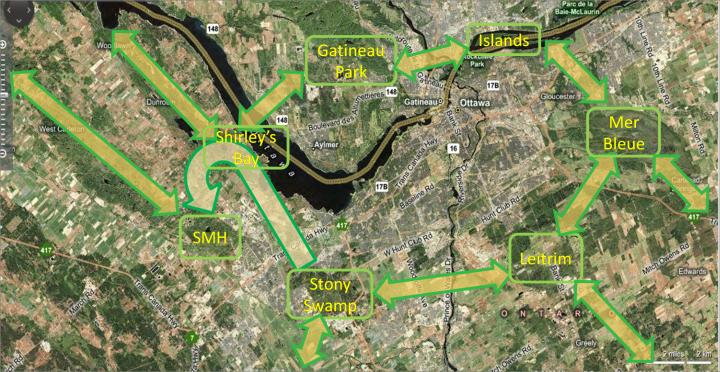
The Emerald Necklace
The Emerald Necklace is a system of eleven eco-corridors linking eight ecological reservoirs: South March Highlands, Shirley’s Bay, Gatineau Park, Ottawa River Islands, Leamy Lake Park, Mer Bleue, Leitrim Area Wetlands, Stony Swamp, and the Marlborough Forest. The location of these eco-corridors is based on existing wildlife corridors and Greenbelt linkages. Embedded in the Emerald Necklace are two corridors that form a Shepherd’s Hook which represents a national symbol of stewardship. The Shepherd’s Hook connects Stony Swamp, Shirley’s Bay, and the South March Highlands.
The Emerald Necklace is described in more detail in Appendix 5.
5.4 Natural environment
-
Biodiversity should be the key element in planning for and managing the Greenbelt. Protecting and enhancing biodiversity requires action well beyond the officially identified ecologically valuable sites. A comprehensive understanding of all of the natural components of the Greenbelt, and their interconnections and interdependencies, needs to be developed. Species at Risk habitats within, and adjacent to, Greenbelt lands must be protected. Common habitats, including scrubland and unmowed meadows, must also be protected.
-
Undeveloped land should remain undeveloped to provide ecological continuity over the whole area of the Greenbelt and allow core areas to expand.
-
The Greenbelt’s contribution to the region’s ecological functions should be explicitly recognized — e.g. air quality, wildlife protection, water quality, flood control, wetland and dryland habitat that enable biodiversity, groundwater recharge, genetic barriers to invasive species, crop pollination and aesthetics — and reflected in policy, practice and educational activities.
-
Certain areas should be restored to their native state. Programs for combating invasive plant species such as Swallowwort, Garlic Mustard and Buckthorn should be developed and implemented.
-
A Native Plants Strategy should be developed and implemented to document existing native plant species and preserve them and their habitat, and to monitor and prevent invasive non-native plants, which are often harmful to existing ecosystems.
-
The diverse wildlife species within the Greenbelt should be recognized, valued and protected. This holds in particular for the ‘non-rare’ species, as they have shown resilience and adaptability. They are part of the mosaic that accounts for the complexity and inter-connections within the Greenbelt’s natural areas.
-
The importance of wetlands and the role of beavers as a keystone species in creating and maintaining these critical areas needs to be better understood and promoted. Wetlands provide important ecological services for humans, as well as support an extensive community of aquatic plants, invertebrates, fish, amphibians, reptiles, birds and mammals. Likewise, the role of deer with respect to forest ecosystems, and coyotes as a top predator need to be better understood.
-
There should be no new motor vehicular transportation corridors within the Greenbelt.
-
Mineral and aggregate extraction should be prohibited within the Greenbelt or adjacent to it.
5.5 Wildlife strategy
-
A comprehensive Wildlife Strategy for the Greenbelt should be developed and implemented, in consultation with community stakeholder organizations and relevant agencies. A Wildlife Strategy for the Greenbelt should be centred on wildlife-sensitive planning. It should be based on an ecosystem approach, taking into consideration the most current research on protecting and enhancing biodiversity, and focus on the prevention of human-wildlife conflicts, as well as public education and awareness programs to mitigate such conflicts. It should be a key element in developing and implementing a shared vision between the agriculture and natural environment areas. Such a vision is required to make the Greenbelt “a model of biodiversity in an urban setting.”
5.6 Agriculture
-
The ecological integrity and viability of the Greenbelt’s agricultural and rural lands should be preserved, protected and enhanced. Farmers should be given incentives to operate Greenbelt farms, and surrounding residential communities should be educated about the benefits and requirements of farming.
-
A shared vision should be developed among stakeholders and the NCC for the integrated management of the natural environment and agriculture lands.
-
Agricultural and rural areas currently not fully utilized should be rehabilitated (wherever possible) to increase soil efficiency and productivity, and improvements should be made to existing farmed land.
-
Natural features should be maintained or created, such as hedgerows between fields that reduce soil erosion and provide wildlife habitat and corridor linkages.
-
Wildlife-friendly management practices should be introduced, e.g., hay cutting should be avoided, if possible, at times or in such a manner as not to interfere with the nests, eggs or unfledged young of ground-nesting bird species.
-
There should be on-going monitoring to protect species against toxic chemical pollution (herbicides, pesticides). A gradual reduction in the use of chemical agents (fertilizers, pesticides, herbicides) should be instituted through regulatory and motivational measures, and buffer zones introduced between chemically treated agricultural land and sensitive wildlife areas, especially watercourses.
-
Wetlands and water bodies should be protected from farm effluents, nutrient run-off and erosion and buffer zones should be created between active farms and sensitive wetlands.
-
New forms of farming (horticulture, organic, vegetable, allotment gardens) should be re-introduced to complement existing operations (guided by the benefits of growing food close to home).
-
The economic viability of farm operations should be improved and enhanced. Farmers need the assurance that they will be able to earn a reasonable return on their labour and investment that encourages the current, as well as future generations to continue farming.
-
Agricultural leases should be coupled with requirements for sustainability, including protection of soil quality, natural features, and natural pollinators.
-
Forestry and tree growing operations should be encouraged.
-
Proposals for extending equestrian trails between Marlborough Forest, the Greenbelt, and Larose Forest are acceptable, but any related infrastructure such as a covered arena should be located outside the Greenbelt.
5.7 Public participation, education, partnerships and stewardship
-
The NCC should establish a Public Participation Policy with respect to the Greenbelt, making a commitment to citizens that administrative and policy processes are open and accessible, respectful of the public’s right to be involved, and responsive to the public’s need for information. It should also provide the foundation for encouraging citizen participation and stewardship, extending reach to non-traditional users and forging partnerships with a variety of constituencies — major points identified at the November 2009 National Visioning Workshop.
-
In protecting the future of the Greenbelt, the NCC should work with community partners to foster stewardship, provide education to mitigate human-wildlife interactions and promote living in harmony with nature. The NCC should make a concerted effort to build a broad base of community partners and a permanent Greenbelt Advisory Committee as part of ongoing advice and assistance with Greenbelt planning, policy and operations.
-
The NCC should exert closer oversight of environmental evaluations and of provincial applications such as for water-taking or discharging involving Greenbelt lands.
Appendix 1 – Greenbelt Coalition Member Organizations
Alliance to Save Our Greenbelt (ATSOG)
Canadian Biodiversity Institute
Canadian Parks and Wilderness Society (CPAWS)
City of Ottawa Biodiversity Task Force
City of Ottawa Rural Issues Advisory Committee (RIAC)
Coalition to Protect the South March Highlands
Conseil régional de l’environnement et du développement durable de l’Outaouais (CREDDO)
Ecology Ottawa
Federation of Citizens’ Associations of Ottawa-Carleton (FCA)
Greenspace Alliance of Canada’s Capital
Ottawa-Carleton Wildlife Centre (OCWC)
Ottawa Field-Naturalists’ Club (OFNC)
Save Our Greenspace
Sierra Club Canada
Appendix 2 – The NCC’s Legal Framework for the Purchase and Disposal of Land
Current regime
The NCC’s authority to acquire real property or dispose of surplus land is derived from the National Capital Act (NCA) and the Financial Administration Act (FAA) and its Regulations:
- subsection 15(1) of the NCA requires Governor-in-Council approval for acquisitions above $25,000;
- subsection 15(2) of the NCA requires Governor-in-Council approval for disposals above $10,000, in accordance with subsection 99(2) of the FAA.
There appear to be no FAA provisions regarding the acquisition of real property.
Under subsection 99(2) of the FAA, an agent Crown corporation may dispose of property and use the proceeds but only in accordance with regulations or the authority of the Governor in Council.
The Crown Corporation General Regulations were issued in 1995. We could not find regulations pertaining to the acquisition of real property. Sections 5 and 6 of these regulations apply to the disposal of property pursuant to subsection 99(2) of the FAA. They allow corporations like the NCC to sell real property at fair market value as follows:
- properties with a fair market value of $200,000 or less; and
- properties valued over $200,000 where the transaction is consistent with the most recently approved corporate plan.
The NCC includes a list of potential property disposals valued over $200,000 in its annual Corporate Plan that is submitted to the Governor-in-Council for approval. The list is not included in the Summary of the Plan which is made public.
Section 6 of the regulations allows the NCC to use the proceeds from sale in a manner that is consistent with its approved corporate plan.
Amendments introduced in Bill C-20 (successor to Bill C-37)
According to the Legislative Summary, the two Bills are “virtually identical” save for an additional clause coordinating the provisions of Bill C 20 with those of the government’s proposed Jobs and Economic Growth Act. Bill C 20 would delete section 15 of the NCA and with it the reference to subsection 99(2) of the FAA. NCC staff has not been forthcoming in explaining what restrictions, if any, it would then face regarding the acquisition or disposal of land.
Note that the NCA, in section 10 (2) (a) and (b), gives the NCC general authority to “acquire” or “sell, grant, convey, lease or otherwise dispose of or make available to any person any property,” subject to any conditions it may impose. Bill C-20 (§8) adds the words “concede, transfer” and “easement or real servitude” to the list of options, but does not diminish this general authority.
Bill C 37 received First Reading approval on June 9, 2009, and was referred to the Transport, Infrastructure and Communities Standing Committee. The Committee received submissions and heard delegations, but had not reported out when the Bill was nullified with the prorogation of Parliament in December 2009. Bill C 20 received First Reading on April 30, 2010.
Appendix 3 – The Natural Environment – More Detailed Analysis and Recommendations
“Ecology and economy are both derived from the Greek word oikos – a house or dwelling. Our survival depends upon the rational management of this home: the space in which life can be sustained.” George Monbiot.
The Greenbelt is undoubtedly one of the greatest assets of our nation’s capital. While many cities are investing in restoring lost natural areas to improve urban sustainability and quality of life, we are very fortunate in already having a well-established “green structure” in Ottawa. Our Greenbelt has a diversity of significant natural area – field, wetland, forest – and agricultural, and heritage landscapes that make a substantial contribution to ecosystem sustainability goals within the National Capital Region, and also support the City of Ottawa’s objectives to work “in harmony with nature” and “to create a green and environmentally sensitive city”.
The Greenbelt provides: a wide range of passive and active recreational opportunities; farmlands; several nationally important ecosystems, such as Mer Bleue and the Medeola Woods; many community-valued natural areas such as Stony Swamp, Green’s Creek and Shirleys Bay; a diversity of habitats, including habitat for species at risk; a variety of ecosystems including rivers, wetlands, various kinds and ages of woodlands, and old fields that are home to meadow bird species. The Greenbelt also performs many largely unseen ecological services such as nutrient recycling, pollination and seed dispersal, climate control, air and water purification, and soil formation. These are vital natural services, without which life on Earth would soon collapse.
“Biodiversity means: the diversity of all life on Earth including genetic diversity, species, ecosystems, and the natural cycles and processes essential to life on Earth such as oxygen production, soil formation, and air and water purification”. Ottawa Region Biodiversity Task Force Report, 2007: City of Ottawa Biodiversity Strategy, 2007
The internationally recognized objectives of greenbelt policy include closely tying greenbelt policy with ‘sustainable cities’ policies to improve air and water quality in urban areas, protect ecological functions, habitats and wildlife corridors, and safeguard rural towns and landscapes from urban sprawl by encouraging the regeneration of derelict and under-utilized urban lands (intensification).
The Greenbelt remains largely intact today thanks to the National Capital Commission (NCC). The degradation of certain areas and the interruption of wildlife corridors has been largely due to the negative impacts of roads and pressures from new residential subdivisions.
In accordance with the IUCN and Canada’s Biodiversity Strategy the NCC has the ability to protect and restore the Greenbelt as a “biodiversity preserve” as part of the National Capital Region’s “Emerald Necklace”, and to showcase to the world Canada’s commitment to biodiversity conservation in its capital city.
Protecting, restoring and expanding Ottawa’s Greenbelt supports Canada’s ratification of the 1992 Convention on Biological Diversity (CBD), the 1995 Canadian Biodiversity Strategy, and the City of Ottawa’s biodiversity strategy and ecological sustainability goals. The Greenbelt could be the beginning of a network of trans-boundary ecological preserves and biosphere reserves to demonstrate Canada’s commitment to the CBD, and also to support Countdown 2010, an international initiative to halt biodiversity loss. What better place for such an initiative than the nation’s capital?
The 1996 Greenbelt Master Plan states that it seeks to safeguard the continuity and diversity of the Greenbelt’s natural environment, and protect its natural areas by buffer zones, with natural links connecting them to each other and to natural areas beyond the Greenbelt to allow the free movement of animals and the continuity of plant life, and to enhance the ecological health and resilience of individual areas and the region as a whole. This remains key.
The Greenbelt includes two nationally important ecosystems: Mer Bleue (a RAMSAR site) and the Medeola Woods (a rare example of an old growth Red Maple, Beech, Hemlock forest), and several other major natural areas, notably Stony Swamp, Green’s Creek, and Shirleys Bay. These areas of highest ecological value are often ecologically linked together by undeveloped greenspace, including wetlands. Such lands are referred to by some, who may have development designs on them, as ‘scrub lands’, but they should not be considered to have lower ecological value merely because they lack the biological richness of the major identified lands. In fact, these lands often provide a diverse range of habitats that support a variety of ecosystems. The ecological integrity provided by a large unbroken area of land is just as important as the intrinsic value of the most recognized areas considered in isolation. In sum, the phrase “the whole is greater than the sum of its parts” best characterizes the value of the entire Greenbelt.
Although Ottawa can be justifiably proud of the diversity of the Greenbelt’s rural landscapes, much needs to be done to protect, restore and expand its natural areas and protect wildlife. The Greenbelt deserves to be permanently protected, and it is in need of a legal designation to prevent it from being viewed as a federal land reserve for urban development or for government facilities. Stewardship and biodiversity concerns should be central. They include the reversal of ecological degradation and destruction, and the protection of ecological diversity and biological integrity that allows for the evolution of natural processes. The Greenbelt is the capital’s largest and most significant natural area. In managing it and the diverse conservation and agricultural lands that it includes, the NCC must ensure that these uses are made compatible. For example, it must ensure that the goal, over time, is to manage farmlands in the Greenbelt organically, and that buffer zones are established between natural areas and farmlands in, and adjacent to, the Greenbelt to protect them from harmful agricultural chemicals, just as buffers are required along rivers to protect aquatic life from harmful contaminants in run-off from roads, golf courses, etc.
Adequate protection of the Greenbelt must involve the concept of ecological stewardship, which promotes long term health and sustainability. and sets an example for other Canadian cities. Unfortunately, it is unclear whether such a notion has been thoroughly embraced by the NCC, or whether it lacks the mandate to act as an effective steward, particularly for those lands that “belong” to other federal departments and agencies. Also, at issue is whether the NCC is responsible for ensuring the restoration of those Greenbelt lands and wildlife that have already been adversely affected. What does seem clear is that there appears to be a lack of active responses by the NCC to reported environmental issues, nor does the NCC appear to be proactive in preventing these problems.
The Coalition recommends that policies for the Greenbelt include:
Stewardship and Protection
-
Acknowledging that the NCC is the steward of the Greenbelt, with a primary duty to protect and preserve its natural state, and not a facilitator or enabler for land developments;
-
Legally protecting the Greenbelt’s functions and boundaries as a biodiversity reserve;
-
Developing a comprehensive understanding of all of the components of the Greenbelt, and their interconnections and interdependencies;
-
Ensuring that the principles of maintaining ecological and territorial integrity and sustainable use and Continuous Natural Environment Greenbelt Master Plan goals are strictly followed to protect the lands, features and ecological processes necessary to sustain a healthy and diverse natural environment;
-
Ensuring that planning within and around the Greenbelt is consistent with the protection of the Greenbelt and its functions.
Ownership, Sustainability and Education
-
Ensuring that federal ownership will remain the primary mechanism for achieving Greenbelt objectives under the stewardship control of the NCC, and that the Greenbelt remains in the public domain as a “national treasure” comprising a large, rural open space running in a continuous belt that is planned and managed for the broad public good;
-
Expanding naturalized and other important Greenbelt areas over time to enhance ecological integrity of both the Greenbelt and the region as a whole;
-
Promoting the importance of the Greenbelt for the national capital’s health and sustainability;
-
Using revenue generated from the Greenbelt to continually offset operational costs, invest in ecosystem protection, restoration, and enhancement to provide a haven for wildlife, and develop promotional and public educational programming.
Biodiversity Enhancement, Maintenance and Protection
-
Protecting all Species at Risk habitats within, and adjacent to, Greenbelt lands;
-
Recognizing, valuing and protecting the diverse species of flora and fauna within the Greenbelt, including the ‘non-rare’ species, as they have shown resilience and adaptability. They are part of the mosaic that accounts for ecosystem complexity and the interconnections between species and ecosystems within the Greenbelt’s natural areas;
-
Restoring broken wildlife corridors and ensuring that all wildlife corridors within the Greenbelt and beyond to other natural areas are protected and maintained;
-
Prohibiting the trapping/killing of beaver and other animals that are necessary for the maintenance of healthy ecosystems. (For example, beavers should not have been removed in 2008 and 2010 from the important SAR Lester Road Wetland);
-
Allowing for the evolution of natural processes;
-
Managing wildlife on broader ecosystem principles, and not on the basis of individual species. Not only is attempting to manage individual species passé from an environmental perspective, but there is a growing body of research and new findings that pertain to forest and wetland ecosystems and the contribution made by various species within these habitats that needs to be considered;
-
Responding to human-wildlife issues with education and prevention strategies that promote coexistence and compatible use between agricultural lands and natural areas;
-
Preserving large areas of meadow bird habitat for North American meadow bird populations, which have suffered a huge decline in numbers due to habitat loss. There are a number of prime locales in the Greenbelt such as the Airport lands south of Leitrim Road, and areas adjacent to the Airport Parkway. (Other such areas include the NCC-owned Southern Corridor.) Other plant and animal species are also dependent on old meadows, and need protection.
-
Preserving scrubland (large shrubby thickets) because they are an intermediate stage between open fields and forests and add to the biodiversity of an area. (Transition zones often have a very rich biodiversity);
-
Preserving and enhancing agricultural lands and, if required, providing incentives to lessees to encourage ecologically sound management of the land;
-
Conducting soil biodiversity inventories in natural areas bordering farmland and in abutting 30-metre wide areas of farmland where pesticides were used prior to the implementation of our recommendation on buffer zones (see bullet 29). Over the following five years, conduct annual soil biodiversity inventories to determine the rate of migration of soil biodiversity from natural areas into the buffer zones and the speed at which chemically-dependant soils can be restored to health;
-
Ensuring that all cultivated agricultural and forestry land uses are compatible with sustainability principles.
Prohibitions and Restrictions
-
Prohibiting any new roads which, in themselves, cause extensive, long-term, environmental damage, including major threats to biodiversity;
-
Continuing to prohibit ATVs and other environmentally destructive recreational vehicles from the Greenbelt, and enforcing the ban. (The ruination in 2008 of an old farmer’s lane south of Medeola Woods is a prime example of the damage that can be done by these vehicles);
-
Properly designing and locating new pathways and bicycle paths to avoid damaging sensitive environmental areas and to protect wildlife, ensuring that local communities are consulted, and making available to them educational resources on the protection of natural areas adjacent to recreational pathways;
-
Providing adequate educational signage to indicate environmentally sensitive areas that should not be disturbed, such as species at risk habitat, and, in some cases prohibiting access to these areas to ensure their protection;
-
Prohibiting mineral or aggregate extraction within the Greenbelt;
-
Commenting on, and taking action against proposed developments along the boundary of the Greenbelt which could negatively impact ecosystems within the Greenbelt; for example, some urban development along the boundary has caused severe degradation of wetland areas within the Greenbelt, such as the areas south of Trapper’s Park and Windsor Park Village. (Another example is the discharge from a Lafarge quarry into Stony Swamp, which should have been prevented or mitigated);
-
Creating a pesticide-free buffer zone around natural areas within the Greenbelt and also around the outer boundaries of the Greenbelt to protect biodiversity;
-
Over time, banning the use of pesticides on farmland in the Greenbelt as farm leases are renewed, perhaps by 10% of the total acreage a year for 10 years (organic growers have determined the viability of this rate of soil restoration). Restore the health of chemically-dependant soils and protect biodiversity. (Farms and golf courses can be managed organically);
-
Mowing old meadows on land that is not leased as Greenbelt farmland once a year only in October after meadow plant species have re-seeded) to discourage woody species from taking over the meadows, and to protect this habitat type for the declining meadow bird populations, as well as other animal and plant species that are dependent upon meadows;
-
Abandoning, where possible, the re-digging of old municipal drains because they can cause considerable environmental damage such as that which occurred along Conroy Road in 2006;
-
Disallowing the construction of storm water ponds in the Greenbelt should any future development take place adjacent to the Greenbelt boundary.
Appendix 4 – Agricultural and Rural Lands – More Detailed Analysis, and Options, Best Practices and Additional Recommendations
Introduction
Agriculture means different things to different social groups or individuals. For the consumers it is a source of food (fresh, healthy and palatable) providing for sustainable living. Governments perceive agriculture as a vital industry. Environmentalists are concerned with agricultural pollution (fertilizer and pesticides runoffs), intense land use, (irrigation, tillage) and crops expansion threatening wetlands and wildlife. Yet, they also see agriculture as a source of new green technologies, reducing carbon emissions and improving air quality. Finally, to the farmers it is a business, a style of living and their livelihood. A farmer’s business acumen requires focusing on consumer preferences and production quotas, managing farm outputs and environmental concerns and yet continue to earn income and sustain their business. Diverging visions and expectations toward agriculture had to be viewed through the context of the National Capital Greenbelt with its unique public ownership and management.
The preliminary findings from public consultations and commissioned papers indicate that all stakeholders agree that the agriculture function needs to be protected and expanded and to “become a role model for the rest of the country on how to do this is an urban setting”.4 This paper will further attempt to merge concerns and expectations to provide a coherent, environmentally sound vision of the Greenbelt agriculture in the future, while being sensitive to the role and business constraints of farmers.
Greenbelt Agriculture
The Agricultural and Rural land designation (also referred to in the 1996 Greenbelt Master Plan as “Vibrant Rural Community”) is one of the three major NCC land designations. The current master plan seems to make the Agricultural and Rural designation a centerpiece of attention. Thus, the policy section emphasizes protecting agricultural lands, supporting farm communities and strengthening agricultural production. The current review foresees “an opportunity to strengthen agricultural production to meet sustainable agricultural practices and to foster pride in the provision of local food products to the City of Ottawa”.5
The 1996 plan further recommends “fostering a wide range of viable and well-managed farms as a way to conserve large, open and diverse rural areas in the Greenbelt” and “enhancing the Greenbelt’s contributions to the regional farm economy and agricultural research”. The present day Greenbelt contains about 90 agricultural units, leased to some 62 private operators. Farming operations include about 30 farms producing cash/row crops, 3 dairy farms, 6 beef, 14 horse farms, 4 greenhouse operations and approximately 20 operations for fruit, vegetables, and flowers. There are four pick-your-own operations and nine produce stands adjacent to the City’s urban area. Three of the Greenbelt farms are certified organic and of those, one (Riverglen) was certified biodynamic.6
“The Greenbelt consists of mainly prime agricultural lands with highly productive soils, and approximately 30% (6300 hectares) of it is dedicated to agriculture”.7 A comparison by classes shows that Greenbelt prime agricultural land (classes 1, 2 and 3) accounts for only 9% less area than do agricultural lands outside the Greenbelt (in Ottawa-Carleton). When class 4 land is included, the difference drops to 6%. With over 50% of the agricultural land in the Greenbelt rated in classes 1 to 4, there is no basis for arguing that Greenbelt agricultural land is of poor quality. However, agricultural land quality may have been downgraded by inappropriate land practices or abandonment. On the other hand, appropriate soil conservation practices and rehabilitation can improve land quality. The 1996 Master Plan recognizes the problem and provides strong direction to conserve soil and preserve its long-term suitability for agriculture.
Studies commissioned by the NCC and meetings with farmers-tenants describe agricultural challenges faced by Greenbelt farming. In addition to the global trends and environmental change, Greenbelt agriculture faces unique set of constraints stemming from the public ownership and public expectations.8
The Challenges
A. Market demand and emerging trends
Climate change, energy crisis, threat of natural or man made disasters brought up new challenges underlying the need for stronger protection of agricultural land. The growing crisis highlights the importance of environmentally sustainable agriculture and the benefits of growing healthy food close to the consumer to lessen the dependence on imported foods and reduce transportation-related pollution (carbon footprint). The 21st century urbanites are increasingly demanding organic grown foods close to home. The “think globally, act locally” philosophy spawned a variety of schemes supporting local food (patriotic food, 100-mile challenge, local living economies).9 The local joint initiative “Choosing our Future” stressed that “sustainable food systems are not simply about farming; they are about resiliency of the farm system in the context of the major trends such as the energy crisis, food security, and development pressure on farm land”.10 Agricultural policy reforms highlighting diverse and locally-based agriculture utilizing innovative strategies (e.g. organic and solar-based agriculture) dominate the agenda.11 It is anticipated that “the (new) Master Plan will be updated with sustainability, food security and resiliency considerations”.12
B. Developmental pressure, infrastructure corridors, institutional use
Developmental challenges are widely recognized by both planners, politicians and residents. The NCC-commissioned study indicated that the “Master Plan is meant to support and enhance the agricultural sector in the Greenbelt, the policy is quite general and allows for a number of interpretations of its intentions, making decision making more complicated and providing less consistency in terms of planning for farming in the future. The result is a lack of a clear vision for the future of Greenbelt agriculture on the part of the National Capital Commission, as well as a lack of a common identity for the farm sector”.13 It was also noted that, “appropriate valuing of agricultural land is needed to prevent it from being seen as the solution for development need”.14 Factors such as trespassing, dumping, encroachment, infrastructure allowances (road widening, sewer expansion) are degrading, fragmenting and decreasing farmland.15 The City of Ottawa “White Paper on Development in the Greenbelt” focused on the unresolved demand for transportation corridors and residential development and suggested encroachment on the Greenbelt to satisfy future needs.
C. Green Economy pressures and ecosystems
Energy crisis, the demand for a clean green economy, anti-fossil fuel concerns and the pursuit of bio-fuels, (especially corn-based ethanol) altered the crop diversity giving rise to a large increase in corn production. Demand for more usable land and the need to increase production triggered other unfavourable environmental impacts. “Due to economic and political pressures, the agricultural industry has also become a major cause of environmental degradation. Farmers have been forced to use modes of production that are unsustainable in the long term. Industrial agriculture is dependent on the maximization of output, meaning an increased need for petrochemical-based inputs, such as fertilizers and pesticides, as well as monoculture crops and destructive soil management practices”.16 UNEP 2010 focuses entirely on green economies and emphasizes fossil fuel and agriculture as having the greatest environmental impacts.17 It recommends dramatically reforming, re-thinking and redesigning the energy and agriculture sectors to generate significant environmental, social and economic returns.
D. Environmental Challenges
According to the UNEP 2007 predictions, global environmental problems (soil erosion, nutrient depletion, water scarcity etc.) will worsen in the coming years.18 Global warming, extreme weather may result in decreased yield. Ontario is seen to become warmer, and to experience more extreme weather, including longer dry spells.19 Soil erosion is also a major concern.20
However, agriculture is a source of problems to other ecosystems. Modern day farming practices, land expansion and increased demand for agricultural produce are affecting not only wetlands but also wildlife and migratory birds, in particular. Decline in some species of migratory birds (bobolink etc.) could be ascribed to changes in land use, grazing cattle and agricultural practices (irrigation, tilling, mowing, harvesting). Finally, one cannot forget that Greenbelt agricultural land also provides environmental benefits improving air quality and the health of Ottawa population.
E. Farmers’ challenge
Greenbelt farmers have to deal with a host of “regular issues” (weather conditions, market demand, price fluctuations and legislative and regulatory demands), and new and emerging trends such as alternative farming and a declining and aging farm population. The NCC study stressed that “both the diversity of farms and number of full-time resident farmers has decreased. Farm assets are deteriorating and farm population is aging”.21
Tenant farmers have compiled a long list of issues that need to be addressed in order to have a “vibrant and sustainable agricultural landscape”. Many issues are related to NCC land ownership, the Greenbelt’s location and the terms of farm leases that are seen as a constraint to long-term investment, stability of the business and productivity. Although the current plan provides direction and protection for long-term agricultural uses, changing conditions may require stronger protection for farmers, improved marketing opportunities and more incentives. Strong policies along with appropriate valuing of agricultural land will also deflect development pressures seeing the Greenbelt as an easy target. Many studies and public comments focused on a need to strengthen public knowledge about the role and importance of Greenbelt farming.
Conclusions and Recommendations
It seems that the proximity of Greenbelt farming to the urban area is ideal for the promotion of modified and model farming practices (e.g. adding horticultural operations, organic farming, vegetable farms and allotment gardens). Encouraging and enhancing farming practices will also ensure that Greenbelt lands can continue to provide fresh produce for the nearby urban areas. Increased productivity of Greenbelt agricultural lands and its wider utilization would in turn improve overall biodiversity. Organic growers, allotment gardening associations and many interested individuals are closely monitoring the progress of the Master Plan Review. The NCC is already stressing Greenbelt potentials such as an agri-tourism destination used to teach people about sustainable farming”.22
Although farming tenants are encouraged to manage leased land sensitively, the Master Plan Review offers a unique opportunity to improve terms for tenants, such as offer incentives, extend leases, and stimulate long-term investment. These are worth considering to make Greenbelt agricultural production a showcase of modern, innovative and environmentally sound practices. This should be done gradually, sensitively and in consultations with all stakeholders. As the Greenbelt remains a public domain, there is a unique opportunity to negotiate and implement best practices to alleviate some environmental problems and improve biodiversity. Issues like chemical use, fossil fuel dependency and wildlife impact are challenging yet the review offers an opportunity to find a suitable solution that would allow farmers to conduct their business efficiently without polluting the environment, allowing wildlife to nest, and wetlands to be protected.
The suggested measures may include legislation (conservation areas, habitat preservation, environmental stewardship), and research and education, as well as modified farming practices (minimizing tilling, modified haying, etc.; the farming community may provide additional suggestions). Various grant programs should be further reviewed to assist farmers wishing to develop habitats on Greenbelt lands (e.g. the Landbird Habitat Program,23 Habitat Stewardship Program for Species at Risk24) or new funding provided for farmers interested in new modes of farming. Marketing opportunities stressing proximity of the produce to consumers and strong support and protection from all levels of government might be needed to develop sustainable Greenbelt agriculture.
Main Recommendations
-
The ecological integrity and viability of the Greenbelt’s agricultural and rural lands should be preserved, protected and enhanced. Farmers should be given incentives to operate Greenbelt farms, and surrounding residential communities should be educated about the benefits and requirements of farming.
-
A shared vision should be developed among stakeholders and the NCC for the integrated management of the natural environment and agriculture lands.
-
Agricultural and rural areas currently not fully utilized should be rehabilitated (wherever possible) to increase soil efficiency and productivity, and improvements should be made to existing farmed land.
-
Natural features should be maintained or created, such as hedgerows between fields to reduce soil erosion and to provide wildlife habitat and corridor linkages.
-
If possible, hay cutting should be timed and/or done in such manner as to avoid interference with the nests, eggs or fledglings of ground-nesting bird species.
-
New forms of farming (horticulture, organic, vegetable, allotment gardens) should be re-introduced to complement existing operations (guided by the benefits of growing food close to home).
-
The economic viability of farm operations should be improved and enhanced. Farmers need the assurance that they will be able to earn a reasonable return on their labour and investment that encourages the current, as well as future generations to continue farming.
-
Agricultural leases should be coupled with requirements for sustainability, including protection of soil quality, natural features, and natural pollinators.
-
Forestry and tree growing operations should be encouraged.
-
Proposals for extending equestrian trails between Marlborough Forest, the Greenbelt, and Larose Forest are acceptable, but any related infrastructure such as a covered arena should be located outside the Greenbelt.
The Greenbelt Coalition further recommends that Agricultural policies and practices for the Greenbelt include:
A. Wildlife, Migratory Birds
The Greenbelt Master Plan review affords opportunities to explore the feasibility and efficacy of agricultural practices aiming at protection of wildlife and migratory and nesting birds in particular. The underlying principle for the Greenbelt must be that leaving the protection of wildlife and ground-nesting birds at the individual discretion of tenants is insufficient for their protection. Ultimately, the NCC as a federal agency is responsible for the protection of migratory birds and other protected species on federal land. The review provides an excellent opportunity to initiate modern agri-techniques and showcase environmentally sound practices.
Habitat Loss and Nesting Protection
-
Improving/diversifying land use (aiming for balance between hayfields, pasture and animals that can use either hay or pasture). Alternating between uses (pasture for livestock during May and June, hay cutting later).
-
Introducing wildlife friendly management practices (e.g. dividing land into smaller fields, using rotational or prescribed mowing, moving hay from centre-field outward to allow fledglings to escape, utilizing flushing bars to allow parent birds to escape, leaving strip cover (buffer) areas undisturbed during the nesting season, utilizing prescribed grazing and burning, using noise cannons to deter nesting in any hayfields that are going to be cut early).
-
Diversifying crops, utilizing hedgerows.
Chemical Impacts
-
On-going monitoring and protection of species against toxic chemical pollution (herbicides, pesticides). Gradual reduction in use of chemical agents (fertilizers, pesticides, herbicides) through regulatory and motivational measures. Introducing buffer zones between chemically treated agricultural land and sensitive wildlife areas.
Wildlife Strategic Management
-
Preparing a comprehensive wildlife strategy providing balance and harmony between species and addressing existing imbalances. Implementing native plants strategy to prevent invasion of non-native plants often harmful to the existing wildlife.
B. Wetlands, Clean Water and Farming
-
Protecting wetlands and water bodies from farm effluents, nutrient run-off and erosion. Providing buffer zones between active farms and sensitive wetlands. Using hedgerows, native plants to prevent run-offs.
-
Encouraging “appropriate evolution of Greenbelt” by introducing environmentally sound practices, organic and alternate farming, reducing/replacing pesticides and fertilizers by alternatives that are friendlier to biodiversity.
C. Diversifying Greenbelt Crops and Farms
-
Introducing new forms of farming, diversify existing crops to reduce the need to defend crops against diseases and pests.
-
“Branding” Greenbelt produce, develop farmers markets.
-
Developing a marketing campaign (exclusive for the Greenbelt).
Appendix 5 – Initial Proposals for Greenbelt Expansion
Introduction
Since its creation in 1958, the National Capital Greenbelt has maintained its general shape and size. Some lands have been sold, mainly for infrastructure projects, and other lands have been severed, e.g. lands south of the Ottawa Airport, for reasons that are clearly unrelated to their ecological and other values. Also, some lands have been added, particularly in the Mer Bleue area. With a 50-year time horizon, the Greenbelt Coalition has begun to use this opportunity to see how the Greenbelt could be enhanced, all within the general context of the Emerald Necklace around the National Capital Region.
In our initial discussions, inspired by Dr. Paul Keddy’s presentation at the National Visioning Workshop, we identified two large, biodiverse, high-priority areas, using a set of criteria we developed (see below). One area is adjacent to the current southern boundaries of the Greenbelt (the Leitrim Wetlands), the other area, although not currently bordering on the Greenbelt, could be made contiguous to it through strategic acquisitions and partnerships with the City of Ottawa and others (the South March Highlands).
We emphasize that the Coalition plans to continue to identify other potential areas for Greenbelt expansion and to issue further updates to this Appendix over the coming months.
Criteria for Expansion of the Greenbelt
Expansion should be considered where such expansion:
-
re-incorporates ecologically significant areas such as the lands around the Airport that were removed from the Greenbelt in 1995;
-
incorporates all of a significant ecosystem of which parts are already in the Greenbelt, whether federally or privately owned;
-
incorporates nearby environmentally significant natural areas;
-
protects nearby geologic or other scientific or important historic features, e.g. ANSIs and PSWs;
-
provides and improve eco-connections/linkages for wildlife or restores broken links;
-
improves recreational trails to nearby significant protected natural areas;
-
protects significant waterways, e.g. cool to cold water streams such as Findlay Creek;
-
protects adjacent/nearby habitat of Species At Risk; and
-
protects adjacent farmland from urban sprawl.
The two priority areas for expansion are the Leitrim Wetland and the South March Highlands.
The remainder of this Appendix discusses these two priority areas in turn.
A. Leitrim Wetland, a Crown Jewel of the Greenbelt
A.1 Overview
Studies have demonstrated that the Leitrim Wetland ecosystem is much larger than the recognized Provincially Significant Leitrim Wetland. A conservative reconstruction of the wetland circa 1830 shows that it covered an area ranging from Blossom Park in the north to the Rideau-Carleton raceway in the south and from the NCC lands east of Conroy Road to the Airport lands west of Uplands Drive.
Three waterways – Findlay Creek, Sawmill Creek and a major tributary of Bear Brook – originate in this ecosystem. About 75% of the Pine Grove (as depicted in the 1991 Ecological Analysis of the Greenbelt), a significant natural area in the Greenbelt, lies within the boundaries of the original Leitrim Wetland and is, in fact, part of this wetland.
The Leitrim Wetland is undeniably a hotspot of biodiversity with at least 541 species of vascular plants, 142 species of bryophytes (mosses and liverworts), 92 species of breeding birds, 15 species of mammals, etc. Three species of Species At Risk turtles – Blanding’s, Spiny Softshell and Snapping – have been observed within its boundaries.
Although the wetland area has been modified and decreased due to the effects of agriculture and urbanization, much of it still survives. The federal government owns the greatest part of the wetland including 30% of the Provincially Significant Wetland.
To ensure the connectivity and long term protection of this important ecosystem, the NCC should re-incorporate those pieces of the wetland and adjacent lands south of Leitrim Road as well as the extant section straddling Bank Street north of Lester Road that was removed in 1996 and acquire, by various means, those parts of the wetland the federal government doesn’t own, along with a sufficient buffer. It should also ensure that the portion of the wetland west of the old C.P.R. right-of-way on Transport Canada lands is not developed because of its ecological significance.
Although it is not possible to restore the whole wetland to its former pre-European glory, there is ample opportunity to enhance/restore large sections which includes allowing certain areas to regenerate naturally.
A.2 Introduction
Over the last 21 years, Albert Dugal, a botanist now retired from the Canadian Museum of Nature, has spent a substantial amount of time studying the historic/original Leitrim Wetland ecosystem. He has written three scientific articles and co-authored a fourth on this important wetland. He also has prepared reports on various components of the ecosystem. His latest work, completed in the spring of 2010, focused on the delimitation of wetland areas in the Greenbelt between the old C.P.R. right-of-way and Uplands Drive. That report was prepared for the Greenbelt Coalition.
A.3 Methodology
The following methodology has been employed in preparing this Appendix.
-
studying of topographic and surficial geology maps, soils maps, aerial photographs using a stereoscope and recent Google satellite images;
-
performing extensive field work, noting plant communities, observing, identifying and/or collecting vascular plant species;
-
preparing diagrams based on the study of various documents and/or field work; and
-
seeking sources of information on other life forms, wetland functions and peat wastage.
A.4 Observations
The 1863 Walling Map of Carleton County (Figure 1) and the 1879 Illustrated Historical Atlas of the County of Carleton (Figure 2) clearly demonstrate that the Leitrim Wetland was much larger than the wetland area that was declared to be a Class 1, Provincially Significant Wetland (PSW) by the Ontario Ministry of Natural Resources in 1989. These maps indicate that the wetland originated south of the Blais Road right-of-way and extended northward to Blossom Park. The Walling Map also indicated that the wetland ranged west of the old C.P.R. tracks north of the present-day Lester Road.
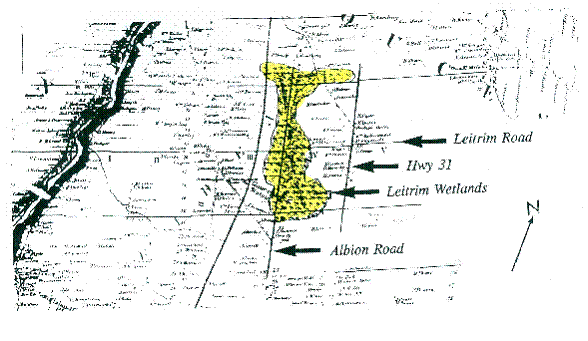
Figure 1. Part of the 1863 Walling Map of Carleton County showing the Leitrim Wetland.
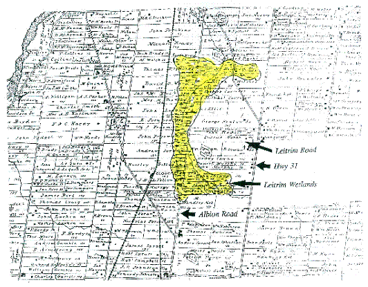
Figure 2. Part of the 1879 Illustrated Historical Atlas of the County of Carleton showing the Leitrim Wetland
Note: the Leitrim Wetland and Stoney Swamp are the only two Greenbelt wetlands that appear in the Belden Atlas. As the Belden Atlas only shows seven of the numerous wetlands that occur in Carleton County, these must have been quite extraordinary. (All seven of these wetlands are PSWs today.)
The 1917 Geology map of the Ottawa area shows an extensive peat deposit that followed Sawmill Creek deep into Blossom Park in the north and extended almost to Uplands Drive in the west. (See Figure 3). As peat can only be formed under wetland conditions, this indicates that the wetland was larger than that depicted in either the Walling or Belden maps.
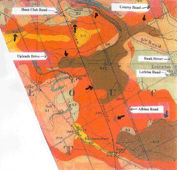
Figure 3. Part of the 1917 Ottawa Surface Geology map showing peat deposits (the dark brown – S12 area) which were formed in the Leitrim Wetland.
The 1917 Geology map also shows peat deposits in the Trappers Park Woods and in an area north of Hunt Club Road about half a kilometre west of Uplands Drive. These organic deposits are also illustrated in an old soils map (circa 1930’s). However, in this later map, the deposits are connected. (See Figure 4.)
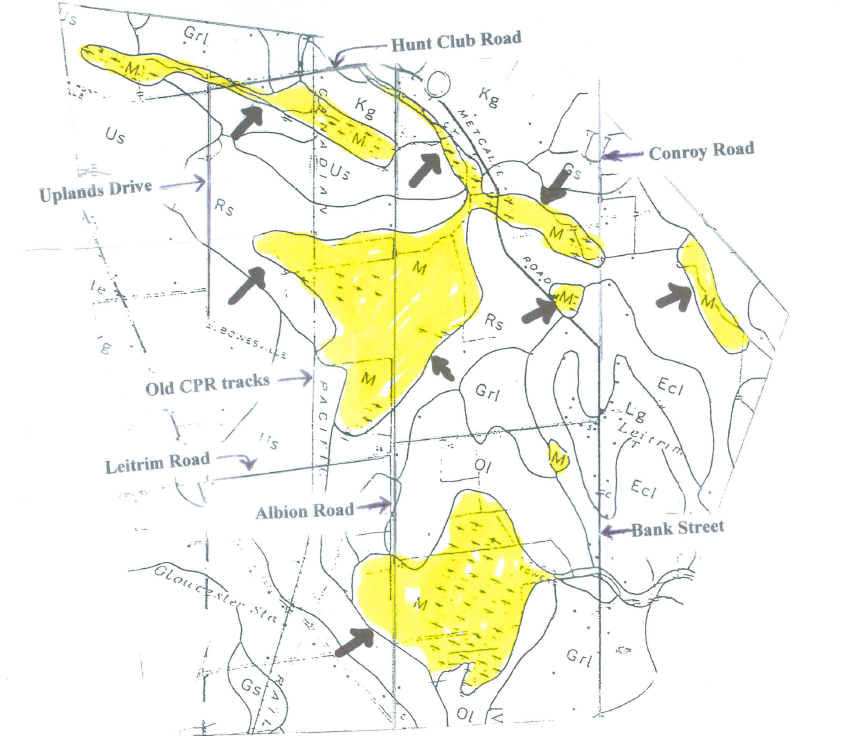
Figure 4. Old Soils map (circa 1930s) of Carleton County showing peat deposits (M) which were formed under wetland conditions.
This delimitation is supported in part by the 1982 Surficial Geology map 1506A. (See Figure 5.)
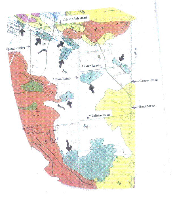
Figure 5. Part of the 1982 Surficial Geology Map 1506A, Ottawa, showing peat deposits (blue spots – 7) which were formed under wetland conditions.
Map 1506A also indicated that the Trappers Park Woods deposit ranged to the east side of Albion Road and was narrowly separated from another peat deposit to the south, which extended into wetland area depicted in the Walling and Belden maps. These maps suggest that the Leitrim Wetland extended north-westward into the present day Hunt Club Golf Club.
The old soils map also shows a peat deposit bordering the east side of Bank Street, south of Lester Road and north of the Conroy Road – Bank Street junction. Considering the nature of the terrain and the moisture-loving vegetation, it is highly likely that this area is part of the Leitrim Wetland ecosystem.
The 1917 Geology map shows that the main branch of Sawmill Creek originates west of Uplands Drive suggesting the presence of a seepage area or wetland. This would be expected due to the topography – i.e. the land rising to the west. Aerial photograph A13637-36 indicates a high level of moisture in the soil of this area and field observation of the land around Uplands Drive supports the information conveyed by the photograph.
Field work and aerial photographs of the area between the old C.P.R. right-of-way and Uplands Drive indicate that much of this area is wetland. Therefore, the original Leitrim Wetland ecosystem, below Hunt Club Road, extended westward beyond Uplands Drive.
Figure 6 shows an approximate and conservative reconstruction of the Leitrim Wetland using the information obtained from the sources listed above.
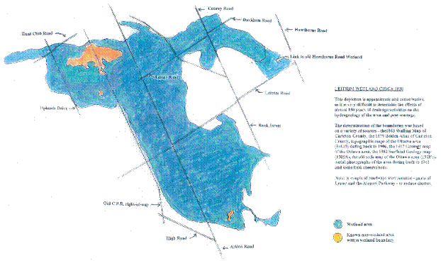
Figure 6. Reconstruction (approximate) of the original Leitrim Wetland Ecosystem.
As depicted in Figure 7, the federal government owns the largest part of this wetland ecosystem.
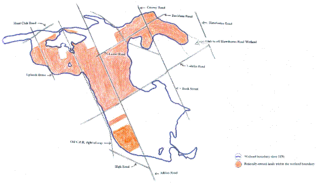
Figure 7. Federally-owned sections of the Leitrim Wetland Ecosystem are shown in orange.
The 1945 and early 1950’s aerial photographs show the maximum incursion of agricultural practices in the wetland ecosystem. Following purchase of much of the historic/original Leitrim Wetland for the Greenbelt, farming ceased in a significant portion and the process of wetland regeneration began which continues to this day. Approximate present-day wetland areas are shown in Figures 8, 9 and 10.
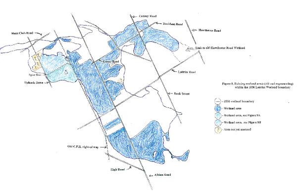
Figure 8. Shows the existing wetland area (old and regenerating) within the 1830 Leitrim Wetland boundary.
Other parts of the original wetland not owned by the federal government were less fortunate and were/are being destroyed by housing developments and industrial parks.
In 1996, the NCC surprisingly removed many acres of ecologically significant land south of Leitrim Road from the Greenbelt. Included in this removal were the federally-owned part of the Provincially Significant Leitrim Wetland and the piece of the Leitrim Wetland between Delzotto and Quinn. At the same time, the NCC also removed two other parcels of land containing parts of the wetland – one straddling Bank Street north of Lester Road; the other between the old C.P.R. right-of-way and the Airport Parkway south of Hunt Club Road.
Fieldwork has indicated that the PSW part of the wetland is the most complex and has the greatest biodiversity with respect to plant life – 500 species of vascular plants and 142 species of bryophytes (mosses and liverworts). There is one Species At Risk (SAR) plant: Butternut; one provincially rare plant; Marsh Valerian; and 56 species of Regionally Significant vascular plants including 7 species found nowhere else in the City of Ottawa.
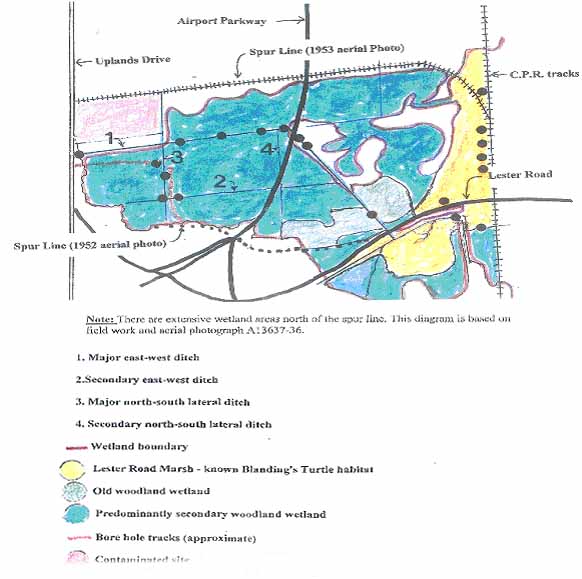
Figure 9. Wetland areas between the old CPR right of way and Uplands Drive south of the spur line. The black circles represent where fish were found to exist.
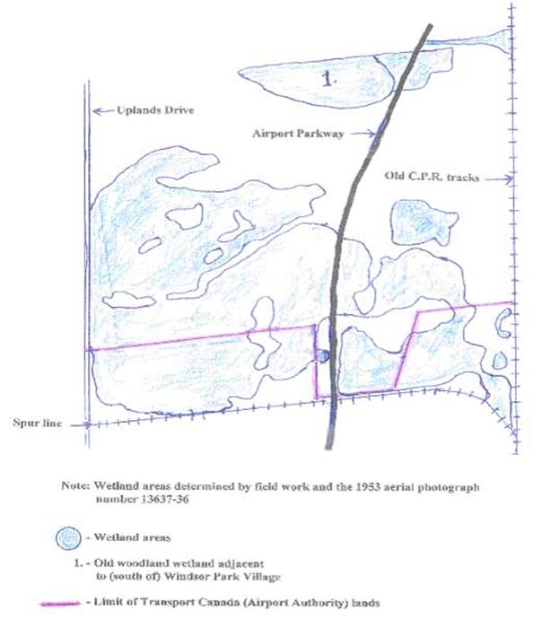
Figure 10. Wetland areas between the old CPR right-of-way and Uplands Drive north of the spur line
Note: The PSW part of the wetland has three times as many bryophytes as the Mer Bleue Wetland.
The PSW also harbours SAR turtles – Spiny Softshell and Snapping Turtles have been observed and, it is highly likely, that Blanding’s Turtles are also present.
The other parts of the Leitrim Wetland contain a good diversity of vascular plants – 160+ species in the Rideau-Carleton Raceway part, 193+ species in the federally-owned wetland area between Delzotto Avenue and Quinn Road, and 296+ species have been noted to date in the Greenbelt wetland areas north of Leitrim Road.
Additional vascular plant species are expected to be found north of Leitrim Road because many of the wetland areas have only had a preliminary botanical inventory.
There are at least 41 species of vascular plants in other parts of the wetland which were not observed in the PSW portion, thus bringing the overall total (to date) for the entire Leitrim Wetland ecosystem to 541.
Species At Risk have also been observed within the boundary of the wetland ecosystem north of Leitrim Road. These include Butternut, Blanding’s Turtle and Snapping Turtle.
Scattered throughout the wetland are patches of old growth where trees ranging from 150 to 200 or more years old can be found. Examples can be found in the PSW, the wetland between Delzotto Avenue and Quinn Road and the Windsor Park Woods.
Due to past drainage schemes and urban development within the boundaries of the Leitrim Wetland ecosystem, there has been extensive peat wastage resulting in the release of “greenhouse “gases into the atmosphere.
According to topographic map 31G/5 Ottawa, the Leitrim Wetland is the headwater area for three waterways – Sawmill Creek, Findlay Creek and a major tributary of Bear Brook.
The Leitrim Wetland is quite different from the Mer Bleue Wetland. The former is primarily a treed fen (with some marsh, bog and swamp components) while the latter is mostly a bog.
The Leitrim Wetland is at least 2000 years older than the Mer Bleue Bog, having originated around 9,800 years ago. It could harbour invertebrate species that are new to science.
A.5 Maintenance, Enhancement/Restoration
The Leitrim Wetland must have been quite awesome prior to the arrival of European settlers. Unfortunately, agricultural practices -land clearing, ditch digging and modifying waterways- and urbanization negatively impacted much of the wetland.
Although it is not possible to restore all of the original wetland to a pre-European settlement state, there is an opportunity to maintain, enhance or even restore that which remains. Prohibition of additional development within the wetland should be a given.
Not all areas can be restored. Trappers Park Woods wetland is one such example. Another is the section of the woodland wetland immediately south of the bypass ditch bordering Windsor Park Village. In these areas probably the best that can done is maintenance. In the case of the wetland woods south of Windsor Park, preventing any massive cleaning or deepening of the bypass ditch would be efficacious.
Enhancing or restoring parts of the wetland involves raising the water table.
In areas of the wetland where housing developments would not be affected by raising water tables, old drainage ditches could be blocked or allowed to fill in naturally with debris and plant growth. Beavers could provide assistance in water retention with their damming activities.
The ditches along roadways that cut through the wetland should not be allowed to be deepened, as this will negatively impact adjacent wetland areas by lowering the water table.
Agreement with the City of Ottawa to abandon Municipal drains or parts of these ditches should be obtained if there will be no effects on urbanized areas. This will allow for long-term enhancement of the wetland along these drainage channels.
To speed up the enhancement/restoration of regenerating parts of the wetland ecosystem, plant species from older, less disturbed sections of the wetland could be introduced – either seeds, spores or living plants.
Stewardship projects with students are excellent for teaching children about the environment, threats to the ecosystem, and a chance to explore the inherent beauty found within the Greenbelt – which unfortunately is largely unknown to so many children. One such project involved four High School Students from Merivale High School, and a few parents. The project took place on April 6 and April 19th 2009 and the goal was to restore the Trappers Woods wetland. The wetland restoration project was a huge success, in that the flow of water was partially (50%) redirected into the woods – providing new habitat opportunities for aquatic species and plant vegetation. Unfortunately this was later destroyed because the tools used (a new bridge for dog walkers) was not seen as a permanent structure. Sadly, after two attempts, we concluded that without the backing of the National Capital Commission these projects will never be successful. Another such project was initiated as a result of a 17 year old dam being removed by the city of Ottawa in October 2008, unfortunately the NCC later dropped the idea, and the long standing wetland and vegetation have yet to recover.
Some of the best areas for enhancement/restoration work include the areas on both sides of the Airport Parkway, the area south of Lester Road, the area on both sides of Bank Street south of Blossom Park, and much of the area south of the Medeola Woods.
A.6 Conclusions
-
The Leitrim Wetland ecosystem is more extensive than the Provincially Significant Leitrim Wetland.
-
Much of the significant Pine Grove area of the Greenbelt is part of the Leitrim Wetland.
-
The Leitrim Wetland ecosystem is undeniably a hotspot of biodiversity.
-
A significant portion of the wetland that was previously cleared for agricultural purposes has regenerated or is regenerating back into wetland. There will be a further increase in wetland as old drains gradually fill with debris and the local water table is elevated.
-
As this wetland is the headwater area for three waterways and habitat for Species At Risk, it should be rigorously protected.
-
Steps should be taken to reduce and halt peat wastage in the wetland. There are methods of augmenting the peat layer in some parts of the wetland – i.e. allowing beavers to dam up old drainage ditches.
-
The portions of the wetland south of Leitrim Road, (about 30% of the PSW and the section between Delzotto Avenue and Quinn Road) as well as the adjacent federal lands should be re-incorporated into the Greenbelt. The extant section of the wetland straddling Bank Street north of Lester Road should also be put back into the Greenbelt.
As the federal government owns the greatest part of the wetland, under the leadership of the NCC, it should acquire:
-
remaining non-federally-owned portions of the wetland east of Albion Road and a buffer zone to protect the wetland’s hydrology; and
-
previously removed parcel of land between the old C.P.R. tracks and the Airport Parkway south of hunt Club Road. These acquisitions would help to ensure long term protection of this significant wetland and its biodiversity. (See Figure 11).
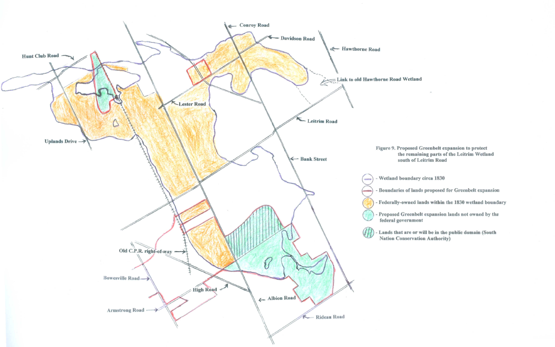
Figure 11. Proposed Greenbelt expansion to protect the remaining parts of the Leitrim Wetland south of Leitrim Road
Much of this suggested expansion area has already been recognized by the NCC in 1991 as being a significant natural area (ref: “Ecological Analysis of the Greenbelt”).
-
It should be noted that about 50% of the PSW east of Albion Road is or will be in the public domain (to be donated to South Nation Conservation Authority).
-
Although it is not feasible to restore all the wetland to its former glory, much of this ecosystem can be maintained or enhanced/restored, by following some common-sense guidelines.
A.7 References
ARDA. 1967. Soil Capability for Agriculture, Canada Land Inventory, Ottawa 31G
Brunton, D.F. 2005. Urban Natural Areas Environmental Evaluation Study, Appendix A – Vascular Plants of the City of Ottawa, with Identification of Significant Species
Consaul, L., R. Boles and A.W. Dugal. 2001. Leitrim Albion Road Wetlands: Its Biodiversity and its Bioblitz. Trail & Landscape 35 (1):16 65
Dugal, A.W. 1990. Albion Road Wetlands Part 1.Trail & Landscape 24 (2): 56 78
Dugal, A.W. 1992. Leitrim Albion Road Wetlands Part 2. Trail & Landscape 26 (3): 64 94
Dugal, A.W. 1993. Leitrim Albion Road Wetlands Part 3. Trail & Landscape 27 (4): 118 139
Hough, Stansbury and Woodland Ltd. 1991. Ecological Analysis of the Greenbelt. National Capital Commission. Ottawa.
Google Maps, satellite images accessed 2010 maps.google.com
Illustrated Historical Atlas of the County of Carleton, 1879. H. Belden & Co. Second reprint edition, 1976. Cumming Atlas Reprints, Stratford, Ontario
Johnston, W.A., 1917. Ottawa, Carleton and Ottawa Counties, Surface geology, Ontario and Quebec, Geological Survey of Canada Multicoloured map No. 01662
National Air Photo Library (Aerial Photos):
Roll No. A9556 Frames 21-26
Roll No. A9557 Frames 14, 16, 18, 20, 22, 24
Roll No. A9558 Frames 16, 18
Roll No. A9609 Frames 42, 43, 44, 87, 88, 89
Roll No. A9610 Frames 51, 52
Roll No. A13102 Frame 29
Roll No. A13510 Frame 441
Roll No. A13365 Frame 34
Roll No. A13637 Frame 36
Roll No. A14570 Frames 8, 9
Roll No. A14755 Frame 88
Roll No. A19864 Frames 119, 120
Roll No. A23612 Frame 11
Roll No. A27398 Frames 47, 48, 49, 58
Roll No. A28361 Frames 142, 143
Roll No. A28465 Frames 200, 201
Roll No. A31326 Frame 135
Roll No. A31398 Frame 32
Roll No. A31489 Frames 34, 35
Roll No. A31732 Frame 145
Roll No. A31788 Frames 156, 157
Richard, S.H., 1982. Surficial Geology, Ottawa, Ontario and Quebec, Geological Survey of Canada, Map 1506A
Soils map of Carleton County circa 1930’s
Topographic Maps 31G/5 OTTAWA, Ontario Quebec, from 1906 to 1998
Walling, H.F. 1863. Map of Carleton County, surveyed by O.W. Gray
B. The South March Highlands in West Ottawa
B.1 Introduction
The South March Highlands (SMH) have been described as a “wild island” of natural landscape within the City of Ottawa. Until recently they remained largely in their original natural state largely because the rugged landscape was unsuitable for agriculture or urban development. The SMH is a distinctive setting in the National Capital from five major perspectives:
-
Visual Distinctiveness
-
Natural Ecosystem
-
Geomorphology & Geology
-
Cultural Heritage
-
Linkages
The SMH also has a proven capability for enhancing the prestige of the National Capital Region as evidenced by a video featuring the SMH being used in the Canadian pavilion at the World’s Fair, and by international sporting events such as the Canadian Orienteering Championships attracting international press attention to the National Capital Region.
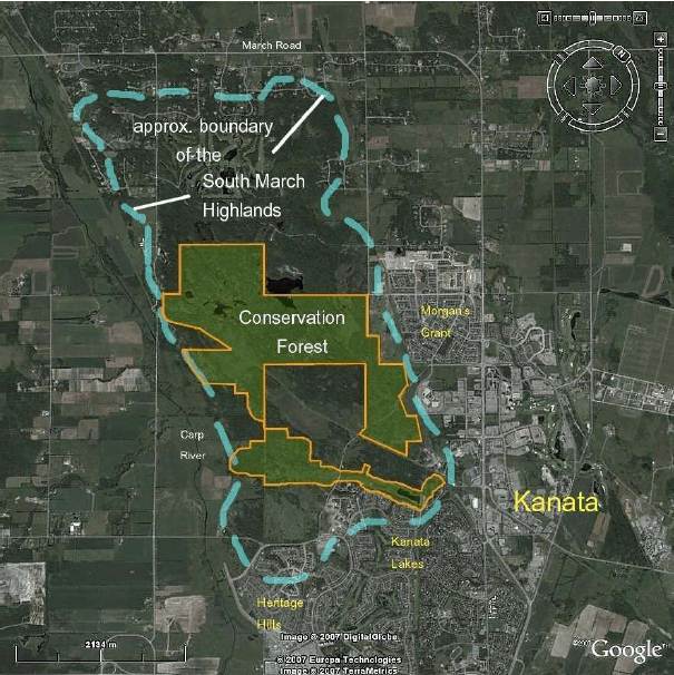
Figure 1. Map of SMH [Brunton 2007]
B.2 Visual Distinctiveness
The SMH provides many diverse, unique, and distinctive visuals that enhance the National Capital Region. The aerial photograph below shows some of the visual diversity that can be found in the SMH ranging from lakes, forests, meadows, rocky ridges, and farmland.
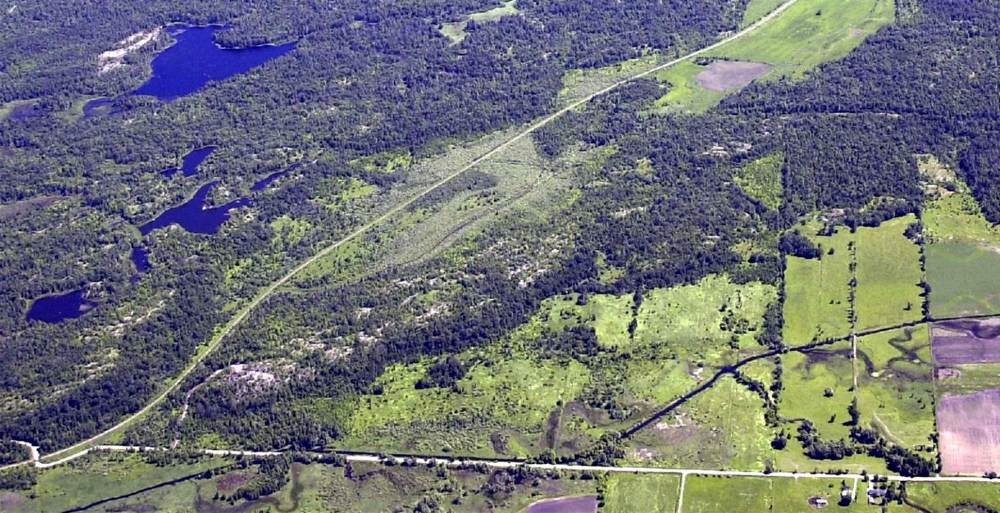
Figure 2. Aerial Photograph of the western side of the SMH
The Beaver Pond at the southernmost tip of the SMH illustrates a natural beauty representative of the Canadian landscape that has been iconified by the Group of Seven.
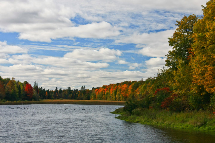
Figure 3. Beaver Pond
The mountain meadows along the Richardson Ridge are unique in the City.
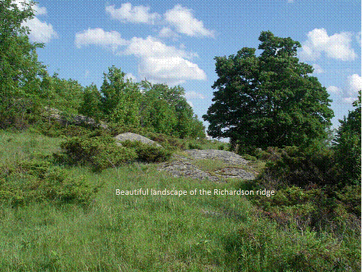
Figure 4 – Meadows along Richardson Ridge
The Carp River valley extends beyond the SMH and brings the agricultural aspect of the National Capital Region into view.
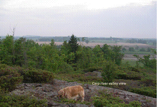
Figure 5 – View of Carp River Valley from Richardson Ridge
B.3 The Natural Ecosystem
No other major city in the world includes within its borders a vigorous old growth forest with endangered species such as the SMH. The closest is perhaps Vancouver’s Stanley Park which is 1/3 the size, contains half the variety of vascular plants, and no species-at-risk (SAR) compared to the SMH.
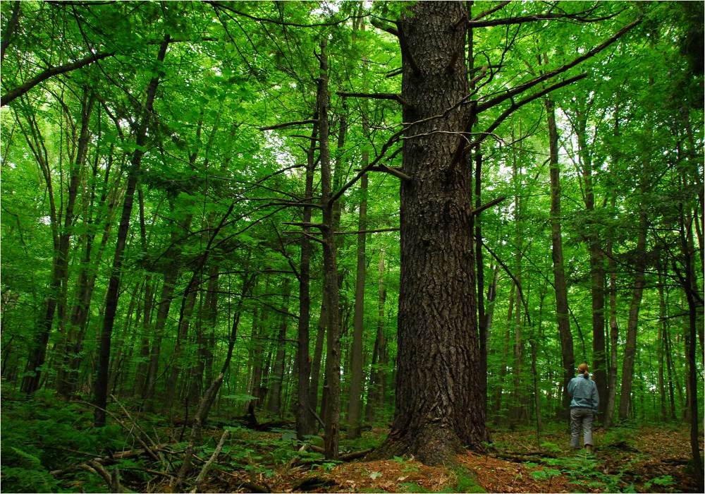
Figure 6. Old Growth in the SMH
The SMH is rated as a Candidate Provincially Significant Area of Natural and Scientific Interest (ANSI) for both its Life Science value (895 hectares) and for its unique Wetland Complex (114 hectares). The area has been valued by scientists as the “most important reservoir of ecological potential” in the City of Ottawa because it has the densest biodiversity and 30 eco-types of vegetation which provide a wide variety of resources for the renewal of depleted natural areas elsewhere. Dr. Jeremy Kerr, a professor of Macroecology at the University of Ottawa has even speculated that the SMH may possibly represent one of the densest bio-diverse areas in Canada.
Diana Beresford-Kroeger, an internationally known and widely respected expert in medical biochemistry and botany has extolled the genetic potential and unique qualities of the SMH:
“The collective genome of this forest is singular. A trunk bole height of 60 –70 feet is common to almost all species [in the SMH]. The boles are straight and true to a covering canopy. This in itself indicates a gene pool of a very ancient source of perhaps 400 million years of development. In the forest itself, there is a 25 foot in circumference fingerprint stool of Fagus grandiflora, the American Beech, just one of many. The White Ash, Fraxinus alba, are the largest in diameter, approximately 5 feet, in the area, if not in Eastern Canada. A natural graft twin between F. alba and Carya cordiformis, the butternut hickory is a scientific first and demands of itself research and investigation. There is also a melding of the Carolinean forest system in these woods, carpinus caroliniana, American hornbeam or bluebeech, stands out as an important medicinal tree of the Birch family. In addition, the increasingly rare Betula Intea, yellow birch, is seen holding its own for height. This tree, too, is medicinal for men.”
There are 10 distinct habitats within the SMH that are home to 18 SAR and one of the largest deer wintering yards (925 hectares) in the City. In addition, the SMH are home to 18 more species that are identified by the federal Committee on the Status of Endangered Wildlife in Canada (COSEWIC) as priorities for SAR candidates. Table 1 summaries the SAR observed in the SMH and Table 2 summarizes the species believed to be extirpated from the SMH.
The SMH are ecologically unique in the City of Ottawa, supporting over 440 native species of vascular plants, including: 64 Regionally Significant, 50 Locally Significant, 6 Provincially Rare, and 2 Nationally Endangered species. It has the highest floristic diversity of any natural area in the City. Of this vascular flora, the Coalition to Protect the South March Highlands has to-date identified 30 native plants that have been traditionally employed for medicine by First Nations.
This habitat is home to 75 species of Mammals, Fish, Amphibians, and Reptiles including 5 species-at-risk and 2 locally uncommon species. The habitat is crucial for 164 species of birds, including 136 species that are known to breed in this area, 9 SAR, and 30 Regionally Significant species that inhabit this ecosystem. The area is also home to the Monarch Butterfly, another species at risk, and possibly other interesting insects, however no study of insect, fungi, or bryophyte (non-vascular plant) species has ever been performed. Ms. Beresford-Kroeger estimates that approximately 40 species of insects can be anticipated for each species of tree found in the SMH.
In 2008, a scientific study of the conservation forest conducted by Daniel Brunton found that
“The [current] ecological integrity of the flora and vegetation in the Conservation Forest is also exceptionally high, as measured by the ‘naturalness’ of the native flora. The native flora of the study area demonstrates an average Coefficient of Conservation (CC) rating of 5.08 – higher than any City of Ottawa Urban Natural Area… The Coefficient of Conservation provides a rating of the ‘naturalness’ of native plant species (i.e. the degree to which each species requires relatively pristine conditions) on a zero to 10 scale, where 0 indicates species having no requirement for natural habitat and 10 indicating taxa which require pristine habitat. Ottawa and eastern Ontario urban natural areas typically average under 4.0.”
However, the same study also warned that “The Conservation Forest is clearly in a fragile state and facing serious challenges to its long term ecological integrity… the Conservation Forest is presently too small to fully represent South March Highlands’ natural features and functions.” Time is of the essence to preserve the remainder of this astounding ecosystem that we are so lucky to have in the City.
|
The following 3 species are Endangered both provincially and nationally: |
|
|
American Ginseng – danger of extirpation |
|
|
Butternut Tree |
|
|
Loggerhead Shrike – possibly extirpated |
|
|
The following species are Threatened in the jurisdictions noted in parenthesis: |
|
|
Blanding’s Turtle (Ontario & Quebec) |
|
|
Whip-poor-will (All provinces east of Alberta) |
|
|
Golden Winged Warbler (Ontario & Quebec) |
|
|
Western Chorus Frog (listed Federally for Ontario & Quebec but not yet listed under SARO) |
|
|
Eastern Musk Turtle (Ontario & Quebec) – possibly extirpated |
|
|
Olive Sided Flycatcher (All Provinces) |
|
|
The following species are of Special Concern: |
|
|
Bridle Shiner – possibly extirpated |
|
|
Short Eared Owl |
|
|
Black Tern |
|
|
Common Nighthawk |
|
|
Snapping Turtle |
|
|
Eastern Milksnake |
|
|
Monarch Butterfly |
|
|
Bald Eagle |
|
|
Red Headed Woodpecker |
|
|
These additional species are on the COSEWIC Candidate List for Ontario (priority shown in parenthesis): |
|
|
Evening Grosbeak (high-priority) |
|
|
Eastern Wood Peewee (high-priority) |
|
|
Wood Thrush (high-priority) |
|
|
Bank Swallow (high-priority) |
|
|
American Bullfrog (mid-priority) |
|
|
American Kestrel (mid-priority) |
|
|
Belted-Kingfisher (mid-priority) |
|
|
Eastern Red-Backed Salamander (mid-priority) |
|
|
Field Sparrow (mid-priority) |
|
|
Blue-Spotted Salamander (low priority) |
|
|
American Toad (low priority) |
|
|
Bluntnose Minnow (low priority) |
|
|
Boreal Chickadee (low priority) |
|
|
Killdeer (low priority) |
|
|
Midland Painted Turtle (low priority) |
|
|
Northern Two-Lined Salamander (low priority) |
|
|
Green Frog (low priority) |
|
|
Wood Frog (low priority) |
|
Table 1. SAR previously observed in the SMH
|
The following species are believed to be extirpated (previously observed in the SMH): |
|
|
Cathcart’s Woodsia |
|
|
Oregon Woodsia |
|
|
Spiny Coon-tail |
|
|
Adder’s-tongue Fern |
|
|
Back’s Sedge |
|
|
Large Duckweed |
|
|
Long-spurred Violet |
|
|
Showy Orchis |
|
|
Southern Arrow-wood |
|
|
Strawberry-blight |
|
|
Virginia Spring Beauty |
|
Table 2. Species previously observed in the SMH and believed extirpated
Some of the SMH are protected through City ownership via a “Conservation Forest” that does not prevent the City from attempting to build a 4-lane highway through the middle of it. The urban natural features inventory conducted for the City’s Greenspace Master Plan identifies the SMH as containing some of the most significant natural areas of the City (Trillium Wood, Beaver Pond, Richardson Forest, and the lands surrounding the SMH Conservation Forest).
B.4 Cultural Heritage
The cultural heritage value of the SMH accrues from both pre- and post- European settlement in the National Capital Region.
Grandfather William Commanda (the most senior Elder of the Algonquin First Nation and a member of the Order of Canada) has declared the SMH to be “an ancient and sacred site [that] is of great archaeological importance to the Indigenous Peoples of the Kichisippi, the Ottawa River Watershed.”
In a recent report, Dr. Robert McGee (a Fellow of the Royal Society of Canada, former Curator at the Museum of Civilization and former President of the Canadian Archaeological Society) outlines the unique archeological value of the SMH, not just for the Ottawa area, but for Eastern Ontario. His report substantiates the traditional knowledge of the Algonquin and is another compelling dimension for the case for preserving of what is left of the South March Highlands, and for their inclusion in an expanded Emerald Necklace. Dr. McGee’s description is as follows:
“In the early postglacial period, between approximately 11,000 and 9000 years ago, this area formed the shore of the Champlain Sea. This was a productive mid-latitude version of a seasonally frozen Subarctic sea, probably combining some of the characteristics of the present Hudson Bay and the northern portion of the Gulf of St. Lawrence. Champlain Sea sediments in gravel pits have yielded the bones of a full range of ice-adapted sea mammals including bowhead whale (Balaena mysticetus), beluga (Delphinapterus leucas) and walrus (Odobenus rosmarus), together with ringed, bearded and harp seals (Phoca hispida, Eringnathus barbatus, Phoca groenlandica).
During this period the Carp Ridge emerged as a series of rocky islands paralleling the southern shore of the sea. These islands were separated from one another and from the shore by narrow channels through which tidal currents, together with those of melt water flowing from the nearby mouth of the Ottawa River, would have produced turbulent mixing of fresh and salt water as well as inhibiting the formation of winter ice. Polynia conditions such as these are very productive locales in Arctic waters, attracting both sea mammals and their human predators.
When the level of the Champlain Sea dropped below an elevation of about 90 metres above current sea level the islands coalesced to form the Carp Ridge, and this was attached to the mainland at the head of a narrow and shallow bay that now forms the floodplain of the Carp River. This new configuration, which took form at some time between 10,000 and 9,000 BP, removed the conditions that would have made the local area an exceptional hunting locality during early postglacial times.
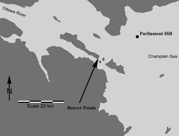
Figure 7. Location of the Beaver Ponds [Southern Tip of SMH] relative to Champlain Sea height of 110m [light grey is under water], approximately 11-10,000 years ago
When this fact is taken into account, the rocky upland areas can be considered to be of high potential for occupation by early postglacial sea mammal hunters along subsequent shorelines as local sea levels dropped from about 120 m above current sea level at around 11,000 radiocarbon years ago, to 90 meters above sea level at some time around 9,000 years ago. The apparent presence of quartz veins in the groundmass of these highland areas would have provided another attraction to early hunters of the time, as quartz was the primary tool-stone used by the early Archaic period occupants of the maritime regions to the east (Gulf of St. Lawrence) and south (Gulf of Maine).
On the nearby Broughton Lands, Swayze (2005, 2009) recovered convincing evidence of a significant Early Archaic occupation along shorelines of the recessional Champlain Sea. This is, in fact, the earliest known evidence of occupation in Eastern Ontario. In fact, a basic knowledge of the physiographic history of the local region makes it apparent that these are the regions most likely to have archaeological potential for preservation of important sites related to the earliest postglacial occupations of the Ottawa Valley area.”
Dr. McGee’s assessment is also supported by Marcel Laliberté’s assessment for the NCC of the Archaeological Resource Potential of the National Capital Region (1998) which emphasizes the importance of sites, such as the SMH, known to be on the ancient shores of the Champlain Sea.
“Although the current portrait of archaeological discoveries in the Ottawa Valley itself indicates relatively late settlement, hardly more than 6,000 years, there is every reason to believe that groups ventured into the NCR much earlier, even when the sea flooded the newly exposed land …. Fluted projectile heads typical or the Early Paleo-Indian period have also been reported as far as the Rideau Lakes region, barely 80 km south of the of the Ottawa River. Furthermore, the vast majority of Early Paleo-Indian sites in Ontario are located near the shores of the Champlain Sea.”
The archaeological sites discovered in the SMH by Ken Swazye were also assessed in-person by Dr. Hansjurgen Muller-Beck (an internationally recognized expert on archaeology and a Professor Emeritus of Paleohistory and Archaeology of Hunting Cultures at the University of Tübingen):
“Those stone fragments are really very scattered remains from raw material stone tool quarries of pre-historic times, sometimes forming clusters of more intense work. The dating of that waste material was open but might go back quite well into Paleo-Indian times.”
The Coalition to Protect The South March Highlands also has recently discovered another site in the SMH that is at the same elevation and very similar in layout to the ones found by Ken Swayze. Artifacts were found that are believed to be similar to the stone fragments assessed by Dr. Muller-Beck. These are currently being considered by the City which has requested assistance from the NCC in evaluating it.
In addition to significant pre-contact cultural heritage, the SMH also contains unique post-contact cultural heritage that is not otherwise found in the Greenbelt. Euro-Canadian settlement of March township began about 1819 and the Richardson Farm area was established in 1820 (the stone house shown in Walling’s 1863 map of the area still stands). When the great fire of 1870 swept across the Ottawa Valley, the SMH wetlands presented a fire resistant barrier that prevented the destruction of Lewisville (now known as South March).
There are several registered archaeological sites in the SMH and some of the more interesting of these include:
-
a Feldspar Mine dating approximately to 1919-1921 (unique in the City);
-
several 19th Century homesteads dating back to 1820 (as old as Pinhey’s Point);
-
Richardson Stone House dating back to approx. 1860 (as old as the Log Farm); and
-
McMurtry’s Tannery built in the 1860s still stands on 2nd Line Road (unique in the City).
Figure 8. McMurtry’s Tannery in the SMH
B.5 Geomorphology, Hydrology, & Geology
The SMH are at the southern tip of the Precambrian Shield bedrock outcrop known as the Carp Ridge which is 500 million to 4 billion years old and represents the only presentation of the Canadian Shield on the Ontario side of the National Capital Region.
The SMH are geologically located along the edge of the Hazeldean Fault and exhibit many examples of glacial scouring and lacustrine activity. Their geology is uniquely complex and the combination with wetland-rich land has been described in the City’s Natural Environment Assessment (done for the City’s Greenspace Master Plan inventory) as “an island of rugged, heavily-glaciated, rocky, Gatineau Hills-like habitat”.
The SMH is approximately 3,500 – 4,000 years older than low lying areas in Ottawa such as Stoney Swamp and Mer Bleue. Adding the SMH to the Greenbelt would incorporate an area higher in elevation to (and therefore much older than) the existing Greenbelt.
The hydrology of the SMH is integral to both the Carp River as well as to the Shirley’s Bay wetland complex in the existing Greenbelt. According to the Shirley’s Brook/Watt’s Creek Subwatershed Study, the SMH supplies approximately half of the basewater flow for the Shirley’s Bay wetland complex.
The SMH is also a unique occurrence of a significant Sandstone Pavement Barren that displays many sedimentary and glacial features as illustrated below. This unique geological feature is approximately 500m in length by 150m wide and once would have once resembled a polished mirror-like surface.
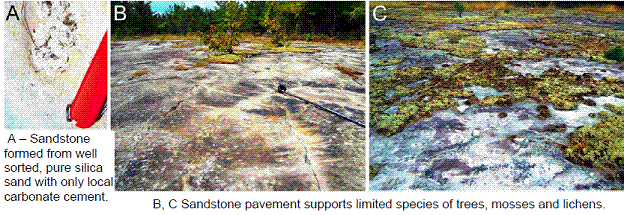
Figure 9. Sandstone Pavement Barren
Notable sedimentary structures, formed during deposition some 500 million years ago, include trough cross bedding, ripples and what may be eroded algal mounds.
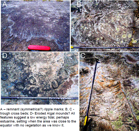
Figure 10. Ancient Sea on Display in the SMH
Other signs of fossilization are also readily found in the SMH:
Figure 11. Ancient Fossil on Display in SMH
As rock-studded glaciers advanced southwards over the Carp Ridge over 13,000 years ago, they left chatter marks, striations, and crescent gouges that are visible today.
Figure 12. Glaciation on Display in SMH
B.6 Linkages
The SMH are linked by air (bird flyways), water (hydrologically), and land (wildlife corridor) to the existing Greenbelt at Shirley’s Bay.
The following map shows the documented wildlife corridors running between the SMH and the Constance Lake-Mud Pond wetland area. This links to a corridor already documented for the NCC by Dave Seburn (Blanding’s Turtle Habitat Mapping, 2008) between the Constance Lake-Mud Pond wetland area and Shirley’s Bay wetlands.
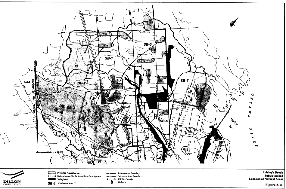
Figure 13. Wildlife Corridors from Shirley’s Brook / Watt’s Creek Subwatershed Study
B.7 Summary
During Part 1A for the Greenbelt Master Plan process the NCC heard 10 key messages from the public consultation. Incorporating the SMH into the Greenbelt as part of the Emerald Necklace supports all of these objectives:
-
Protect the Greenbelt – by protecting key wildlife linkages and the upstream water source for Shirley’s Bay wetland complex;
-
Greenbelt as Sustainability Showcase – by protecting the many SAR in the SMH;
-
Communicate Greenbelt Values – by initiating a visible expression of these values through a high-profile initiate to protect the SMH;
-
Keep Greenbelt Publically Owned – by collaborating with the City who has existing public ownership of part of the SMH and expanding public ownership over privately held SMH lands;
-
No Net Loss Policy – by tapping into the bio-resources of the SMH and other ecological reservoirs to replenish the stress on the existing Greenbelt;
-
Add More Land to the Greenbelt – by augmenting the Greenbelt with additional land purchases in the SMH;
-
Recognize Greenbelt as part of Survival – by recognizing the importance of macro-ecosystem values to survival and that eco-corridors and eco-reservoirs such as the SMH are key to the implementation of those values;
-
Limited Smart Growth – by ensuring that the Emerald Necklace balances growth and by preventing unsustainable growth in the SMH;
-
Greenbelt Appreciated by Public – by incorporating the SMH that is well appreciated by thousands of citizens; and
-
Creatively Revisit the “Belt” in Greenbelt – by incorporating a “Shepherd’s Hook” linking the existing Greenbelt to SMH and creating a national symbol of stewardship.
FOOTNOTES
1 City Hall White Paper and rebuttal
2 Plan for the National Capital, 1950, available at https://qshare.queensu.ca/Users01/gordond/planningcanadascapital/link.htm
3 City Hall White Paper and rebuttal
4 http://www.ottawacitizen.com/life/Bountiful+opportunities+produce+Greenbelt/3064459/story.html#ixzz0uwXFGcax [no longer online]
5 CIELAP’s
4th Partnering for Sustainability Workshop “Achieving Resilient Agricultural Systems: Innovation, People and Partnerships”, November 13 and 14, 2008 – 111 Sussex Dr., Ottawa, Ontario
6 What is Biodynamic Agriculture | Society for Bio-Dynamic Farming and Gardening in Ontario Biodynamic agriculture focuses on enhancing the life processes of nature, to create self-contained farm individualities. Each BD farm develops its own identity based on the relationships between the animals that provide fertility for the soil, the fields that provide food for animals and people, the plant life, the meadows, the orchards, the forests and the wetlands giving space for birds, insects and other wildlife. These interrelations support a healthy farm capable of producing quality, health-giving products.
7<<…>>[quote from 1996 GB MP?]
8 Canada’s Capital Greenbelt: Moving towards Sustainable Agriculture Farm Research Project Wayne Caldwell, PhD, MCIP, RPP Katie Temple, MSc (candidate), School of Environmental Design and Rural Development University of Guelph, July, 2009. Prepared for the National Capital Commission.
9 http://en.wikipedia.org/wiki/Local_food
10<<…>> [quote from a Choosing our Future report]
11The “Buy Local Guide” features local farms and markets in Ottawa, encouraging links with local farms and markets. Other local food initiatives include “Savour Ottawa”. The City of Gatineau has an agricultural development program in place that aims to protect agricultural land; diversify agricultural activities; provide support, including marketing, to sustain agricultural producers and encourage new ones; and more. It includes investment and the establishment of an agronomist to support agriculture and secure additional funds for local producers and consumers. In 2004, the City of Gatineau Council adopted a Farm Development Plan, which aims to protect agricultural lands, develop strategies for use of agricultural land in peri-urban areas, and diversity the agricultural sector with agricultural tourism, use of biomass as part of agro-forestry efforts, and more. Ibid.
12 CIELAP’s 4th Partnering for Sustainability Workshop “Achieving Resilient Agricultural Systems: Innovation, People and Partnerships”, November 13 and 14, 2008 – 111 Sussex Dr., Ottawa, Ontario
13 Canada’s Capital Greenbelt: Moving Towards Sustainable Agriculture Farm Research Project Wayne Caldwell, PhD, MCIP, RPP Katie Temple, MSc (candidate), School of Environmental Design and Rural Development University of Guelph , July, 2009 Prepared for the National Capital Commission
14 CIELAP’s 4th Partnering for Sustainability Workshop “Achieving Resilient Agricultural Systems: Innovation, People and Partnerships”, November 13 and 14, 2008 – 111 Sussex Dr., Ottawa, Ontario.
15 Ibid
16 Canada’s Capital Greenbelt: Moving Towards Sustainable Agriculture Farm Research Project Wayne Caldwell, PhD, MCIP, RPP Katie Temple, MSc (candidate), School of Environmental Design and Rural Development University of Guelph , July, 2009. Prepared for the National Capital Commission.
17 http://staging.unep.org/Documents.Multilingual/Default.asp?DocumentID=620&ArticleID=6538&l=en
18 http://www.unep.org/wed/2007/english/Information_Material/index.asp [no longer online]
19 http://www.acer-acre.org/ClimateChangeCD/sec5/521c.htm [no longer online]
20 Canada’s Capital Greenbelt: Moving Towards Sustainable Agriculture Farm Research Project Wayne Caldwell, PhD, MCIP, RPP Katie Temple, MSc (candidate), School of Environmental Design and Rural Development University of Guelph , July, 2009 Prepared for the National Capital Commission
21 ibid
22http://www.ottawacitizen.com/life/Bountiful+opportunities+produce+Greenbelt/3064459/story.html#ixzz0uwZGRAVJ [no longer online]
23 Ontario Landbird Conservation Plan
24 http://www.ec.gc.ca/hsp-pih/default.asp?lang=En&n=59BF488F-1